


- 5:45 h
- 16.34 km
- 1,174 m
- 256 m
- 1,125 m
- 2,243 m
- 1,118 m
- Start: Feutersoey
- Destination: Col du Sanetsch
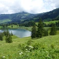
First a flat and leisurely start along the Saane river to Gsteig, where the climb – Nomen est Omen – to Col du Pillon begins. Ours too, but much steeper through the wild 'Rotegrabe' up to the Sanetsch dam. Anyone hiking here on a nice weekend will hardly be alone, as the attractive area is a popular excursion destination both from the Gstaad side (with cable car) and from the Valais side (post bus, access road). With the lake, the wide green areas with ringing Ehringer cows, the gray rocky fields, the Tsanfleuron glacier and the flower-covered meadows, dramatic contrasts arise that leave a lasting impression. From the dam (with restaurant) via the pass summit to the hotel on the access road to Savièse is then just a walk with few elevation meters. The pass offers us a grand view of the Valais Alps, dominated by Dent Blanche, Matterhorn and Dent d'Hérens.

Good to know
Pavements
Best to visit
Directions
Feutersoey (1131 m) – Gsteig (1183 m) – Rotegrabe – Sanetsch Dam (2048 m) – Col du Sanetsch (2253 m) – Hôtel du Sanetsch (2046 m).
Variant: Cable car from Gsteig to Sanetsch Dam. It is possible to combine this with the next stage to Derborence, which results in a hiking time of about 9 hours.
Equipment
Directions & Parking facilities
Arrival: By bus to Feutersoey.
Return: From Col du Sanetsch by post bus to Sion, with train connection there.
Additional information
Gstaad Saanenland Tourism, Tel. +41 (0) 33 748 81 81, www.gstaad.ch
Places to eat, e.g.:
Restaurants in Gsteig; Auberge du Barrage du Sanetsch.
Accommodation:
Hôtel du Sanetsch, 027 395 56 56, www.hotel-restaurant-sanetsch.ch
Literature
Wandermagazin SCHWEIZ, Issue 2/2021, Photo Edition: From Basel to Mont Blanc. Rothus Medien, Solothurn, www.wandermagazin-schweiz.ch
Jochen Ihle / Toni Kaiser: The 101 Most Beautiful Hikes in Switzerland. ISBN 978-3-03865-041-6, Rothus Medien, Solothurn, www.wandershop-schweiz.ch
License (master data)
Author´s Tip / Recommendation of the author
Safety guidelines
Map
Nearby

