


- 6:00 h
- 15.79 km
- 820 m
- 1,620 m
- 773 m
- 2,175 m
- 1,402 m
- Start: Gurnigel/Wasserscheide
- Destination: Weissenburg
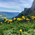
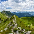
Day 1: From the Wasserscheide bus stop, follow a wide path along the signposting towards Leiterepass. The Alp Obernünene is quickly reached. The hiking trail continues up to Leiterepass, where a magnificent panorama of the Bernese high Alps is visible for the first time. The marked path runs on the right side through the southern flank of Gantrisch and meets below Schibespitz on its southwest ridge. Keeping right, first the ridge is followed; the slightly exposed final ascent to the magnificent panoramic summit of Gantrisch then runs slightly to the right of the ridge. The descent follows the ascent route. Back at the junction, stay on the ridge, which leads over Schibespitz to Morgetepass. Passing Alp Obriste Morgete, go southwards downhill to the already visible Alp Morgeten.
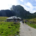
Day 2: From Alp Morgeten, the hiking trail leads downhill over pastureland. At the houses Undriste Morgete, you reach the road. After four hairpin bends, a path on the right shortens the road route. Then the road continues again until you cross the Leiternweide suspension bridge high above the Morgetebach on the left. Afterwards, you descend via the Leiterweg into the gorge until the place where the Morgetebach and Buuschebach flow together. Along the stream, you soon pass the former Hintere Weissenburgbad, where you change to the other side of the stream. At the junction immediately before the former Vordere Weissenburgbad, take the left path, which finally leads to Weissenburg station.
Text: Bernd Jung

Good to know
Pavements
Best to visit
Directions
Gurnigel – Gantrisch – Alp Morgeten – Weissenburg
Equipment
We recommend the following equipment: sturdy hiking boots, medium-sized backpack with hip belt, sun protection, rainwear, hiking poles, small first aid kit, picnic, sufficient fluids, mobile phone.
Directions & Parking facilities
Arrival: by bus to Gurnigel/Wasserscheide
Return: by train from Weissenburg
Additional information
Berner Wanderwege, 031 340 01 01, info@beww.ch, bernerwanderwege.ch
License (master data)
Author´s Tip / Recommendation of the author
Tip
As an alternative, you can take a detour (signposted) from the junction at the suspension bridge to the caves around Mamilchloch and Schnurreloch (an additional 1 h 30 min to 2 h).
Safety guidelines
Requirements: fairly easy mountain hike mostly on white-red-white marked trails (T2); only the final section to Gantrisch is somewhat exposed and equipped with wire ropes (T3).
Map
swisstopo hiking map: 253T Gantrisch, 1 : 50 000
Nearby