


- 3:00 h
- 9.61 km
- 116 m
- 780 m
- 559 m
- 1,175 m
- 616 m
- Start: Heiligenschwendi
- Destination: Oberhofen
If you are ever in Heiligenschwendi, you should also climb the Vesuv. It does not spit fire but offers a wonderful view over the Lake Thun region. Bus No. 32 stops right at the foot of the Vesuv (Stapfebode stop). The more frequent No. 31 stops at "Alpenblick". From there it is a short stretch of road to the Vesuv.
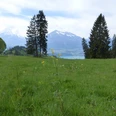
Afterwards, go back past the rehab center and on forest paths to the Niesenbänkli. The name is program: The view of the Lake Thun pyramid is dreamy. The hiking trail now leads directly down the meadow. If it is not yet mown, it is a wonderful feeling to follow the trail through the tall grass and stroke the delicate flower stalks with your hands.
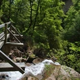
Over field and forest paths, over wooden steps in steeper slopes and through a stream bed it goes to Ober Allmit. A few meters below, a long wooden staircase along a conglomerate wall leads into the geologically exciting area of the Balmflue. Conglomerate blocks and towers the size of apartment buildings are scattered in the forest. They are said to be ancient rockfall deposits. The hiking trail winds romantically around the impressive colossi. At the signpost it is important to choose the shorter path to Oberhofen (not via Bloch). The path then winds further around the rock rubble, leads again through the stream bed and down to Oberhofen to the castle.
The picture-book castle dates from the 12th century and was repeatedly expanded and rebuilt until the 19th century. The park and the lakeside path are freely accessible and a tour is worthwhile. The museum leads through the history of the castle and its former owners. A special feature is the exhibition in the servants' bedrooms, where the everyday life of the servants of the time can be vividly experienced.
Fredy Joss

Good to know
Pavements
Best to visit
Directions
Heiligenschwendi – Niesenbänkli – Chrinde – Oberi Allmit – Balmflue – Oberhofen
Equipment
We recommend the following equipment: Light trekking shoes, light backpack, sun protection, rain jacket, pocket pharmacy, light picnic, sufficient liquids, mobile phone.
Directions & Parking facilities
Arrival: from Thun station by bus to Heiligenschwendi. No. 31 to Alpenblick or No. 32 to Stapfebode.
Return trip: from Oberhofen a.T., village by bus to Thun station or to Interlaken. Or add a relaxing boat trip.
Additional information
Berner Wanderwege, 031 340 01 01, info@beww.ch, bernerwanderwege.ch
License (master data)
Author´s Tip / Recommendation of the author
Tip
Note: At the Balmflue, the hiking trail may be closed due to storm damage.
Alternative: via Underi Allmit via Burhalte to Oberhofen
Safety guidelines
This route runs exclusively on signposted paths of the hiking trail category.
Map
swisstopo hiking map: 253T Gantrisch, 1: 50,000
swisstopo hiking map: 254T Interlaken, 1: 50,000
Nearby


")
")