


- 3:15 h
- 9.04 km
- 496 m
- 496 m
- 1,646 m
- 2,096 m
- 450 m
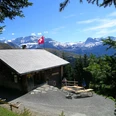
- Start: Bühlberg
- Destination: Bühlberg
The tourist resort Lenk is the uppermost municipality in the Simmental. The first documented mention of Lenk as "an der Leng" dates back to the year 1370. The valley is known worldwide thanks to the Simmental spotted cattle. An important economic factor is winter sports. Its facilities accompany this hike.
From the Bühlberg bus stop, the hike gently leads via an alpine path up to the Hahnenmoospass. Here, the view opens towards the Entschligetal valley in the direction of Adelboden. The Hahnenmoospass is known as the mecca for model glider pilots. The restaurant on the pass operates a dedicated construction hut for this purpose. From Hahnenmoospass, follow the signpost indication Metschstand. Shortly, you reach the reservoir lake, which in winter is used for snowmaking on the pistes. In summer, the lake is planned to enrich the hiking area as an adventure spot (bathing prohibited!).
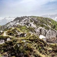
Next follows a section with the character of a panoramic path leading up to the Metschstand viewpoint. Here you encounter the "Stand-Xpress" cable car, newly opened in 2014. The 10-person gondola lifts skiers in winter in just a few minutes from the Lenk valley floor up to the Metsch ski area. The summer operation of the cable car and the operation of the Standhütte restaurant are initially planned for the main holiday season in July and August. The newly created starting point is a valuable addition to summer tourism in Lenk.
The return path to Bühlberg goes via a steep and slippery descent when wet to Metschhore. From there, follow the alpine path to the huts of Metschberg at point 1757. To avoid a longer distance on hard surface, choose not the direct path to Bühlberg but descend through an alpine pasture towards Metsch until the next signpost with local information. Via Metschmad, you will reach the starting point at Bühlberg again without major altitude differences.

Good to know
Pavements
Best to visit
Directions
Equipment
Directions & Parking facilities
Additional information
Literature
Hiking book Circular hikes of the Bernese Hiking Trails
License (master data)
Author´s Tip / Recommendation of the author
Safety guidelines
Map
Swisstopo Hiking Map 263T Wildstrubel 1:50,000
Nearby