


- 6:20 h
- 16.36 km
- 1,250 m
- 1,200 m
- 782 m
- 1,853 m
- 1,071 m
- Start: Weissenburg, station
- Destination: Oberwil i.S. station
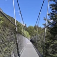
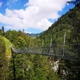
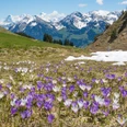
The varied 2-day hike starts at Weissenburg station. You walk on the Via Casea, partly along restored dry stone walls towards Weissenburgbad. Via Casea brings the cultural heritage of Alpine cheese closer to hikers. On a good path you reach the remains of the front bath, which was even visited by royal dignitaries. Here you learn a lot about the great past of the facility built in 1849 and burned down in 1974. On a narrower path to the rear bath you can refill “Weissenburger” at a little spring. Soon you reach the restored remains of the older, rear bath, where the first bathhouse was built as early as 1606. The good reputation of the healing water led to enormous demand and the construction of the spa house. Hard to believe that roaring ball nights were once celebrated at this remote place. Now follows the most strenuous part of the hike, the ascent up stairs well secured with ropes to Leiterenweide. The suspension bridge crosses the Buuschebach roaring 111 m below. It continues on a good path past Schöne Bode, foaming waterfalls, and Undriste Morgete to the stage destination Mittliste Morgete. It’s amazing what this beautiful place offers: catering with natural products, whey baths, and overnight accommodations from simple to luxurious. The next morning, after a hearty breakfast, it goes towards Schattige Riprächte and Schattigseeli. Through beautiful mountain scenery with great plant diversity the highest point of the route, Lohegg (1852 m), is reached. On the right side, the imposing Widdersgrind with its military installations from World War II, still visible today. Then it goes downhill to the final destination, Oberwil station. Full of impressions from the varied alpine landscape, BLS brings us home again.

Good to know
Pavements
Best to visit
Directions
Equipment
Directions & Parking facilities
Outbound: By Lötschberger to Weissenburg: stop on request
Return: By train from Oberwil i S
Additional information
License (master data)
Safety guidelines
Map
swisstopo hiking map 253T Gantrisch 1:50 000
Nearby