


- 4:00 h
- 9.52 km
- 760 m
- 750 m
- 1,932 m
- 2,611 m
- 679 m
- Start: Hahnenmoospass
- Destination: Engstligenalp
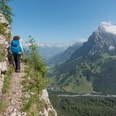
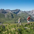
From Geilsbüel take the gondola lift to the starting point Hahnenmoospass and follow the white-blue-white signage directly towards Ammertespitz. Without major altitude differences, you soon stand before the distinctive rock formation of Rägeboldshore. This is bypassed on the north side until the path meets the Bummeregrat. On the ridge, the white-blue-white marked Äugi-Lowa route to Ammertespitz begins. Initially still on or near the ridge, you soon encounter several iron ladders, at the end of which – under a rock overhang – there is a shelter hut. Through a narrow rock passage you enter the southern flank, where a stony path leads to another ladder. After this, the path leads back to the ridge on easy terrain, where the last 70 meters in altitude are covered on the flat, scenic northwest ridge (also called Äugigrat) of Ammertespitz. In a few minutes you reach the highest point of the mountain, where the view into the high alpine setting of the Wildstrubel is impressive.
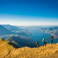
The descent route to the endpoint Engstligenalp can already be seen from the summit. Until the Ammertepass, the descent runs along the southeast ridge. A mountain hiking trail takes you from the pass in about half an hour down to the extensive high plateau of Engstligenalp. Finally, there remains a 3-kilometer pleasant walk with gentle altitude loss to the Engstligenalp mountain station.

Good to know
Pavements
Best to visit
Equipment
We recommend the following equipment: sturdy mountaineering boots, medium-sized backpack with hip belt, sun protection, rainwear, hiking poles, first aid kit, picnic, sufficient fluids, mobile phone.
Directions & Parking facilities
Arrival: by bus from Frutigen station via Adelboden to the Geilsbüel valley station
Return: by bus from the valley station below the Birg via Adelboden to Frutigen station
Additional information
Bernese Hiking Trails Association, Bern, Tel.: 031 340 01 01, E-mail: info@beww.ch, homepage: www.bernerwanderwege.ch
Literature
License (master data)
Safety guidelines
Map
Nearby