


- 3:30 h
- 10.46 km
- 480 m
- 480 m
- 1,759 m
- 1,987 m
- 228 m
- Start: Meienbergalp
- Destination: Meienbergalp
What one wouldn’t suspect: This hike lies within the municipality of Zweisimmen. Geographically, the part of the area that drains into the Diemtigtal belongs to the Diemtigtal and was therefore also included in the perimeter of the Regional Nature Park Diemtigtal.
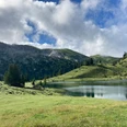
At the starting point Meienbergalp Pt. 1851, follow the signpost indication Seebergsee. Across pastures, first without major elevation changes, then ascending, the saddle Pt. 1921 is reached. To the left, the Niderhore can be seen, a lesser-known namesake of the popular excursion destination reachable by gondola at Lake Thun. Now, surprisingly, the Seebergsee appears, which you approach descending. At the signpost by the lake, turn right towards Stierenberg (Stierenseeberg). A last look at the Seebergsee is worth it. On a forest road, go between the mountains Muntiggalm on the right and Seehore on the left, past the alp Stierenberg, then ascending through a pasture to the Gubi saddle. Here, the view opens westwards to the Vaud and Fribourg Alps. After a descent, continuing to the right through pastures, Hinder Chumi is reached. From here, follow the signpost to Meienbergalp. Through pastures, alternating flat, up- and downhill over Ober Muntigli, you return to Meienbergalp. In this way, both the Seebergsee and the mountains Muntig- and Chumigalm are circled.

Good to know
Pavements
Best to visit
Directions
Equipment
Directions & Parking facilities
Outbound: By train to Zweisimmen, by hiking taxi to Meienbergalp. Note: The hiking taxi only runs by reservation, at fixed times, and on selected days from June to October. Information and reservation at Zweisimmen Tourism, Tel. 033 722 11 33
Return: By hiking taxi from Meienbergalp to Zweisimmen, then by train
Additional information
License (master data)
Safety guidelines
Map
swisstopo hiking map 263T Wildstrubel 1:50,000
Nearby

