


- 5:25 h
- 17.21 km
- 400 m
- 608 m
- 1,093 m
- 1,564 m
- 471 m
- Start: Ramslauenen, chairlift
- Destination: Kandersteg
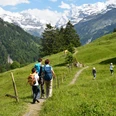
Starting from the hiking start at the Ramslauenen mountain station, the route is consistently called the Nordrampe BLS high path. It is also part of the Lötschberg Panorama Trail 56 from Wanderland Schweiz, running from Kiental to Fafleralp in Lötschental. Initially, the route ascends over an alpine pasture. Here you should enjoy the view of the Kiental, Wätterlatte, and Dreispitz. Then follows a stretch through forest where the path becomes flatter. Before Chüeweid, the direction changes from north to south. Now there is a clear view of the lower Kandertal, Lake Thun, Niesen, Sigriswilergrat, and Niederhorn. At Chüeweid, a fire pit with benches invites you to pause. The continuation is varied: on a path, sometimes through forest, sometimes over pasture upwards, then downwards again to Höreli. Along the way, you get a glimpse into Kandertal and Frutigen. Now the route descends, first on a road to Schlafegg, then on a path through forest to Bundergrabe. Suddenly, a shelter with tables and benches appears, fittingly about halfway through the hike. It continues through the Rone forest, passing another rest stop. Above Mitholz, you meet the railway experience trail Kandersteg–Frutigen. After a longer forest section, the hike runs near the tracks of the BLS mountain route and the Frutigen–Kandersteg cantonal road. At Büel, there is a stone inscribed “XIII hours from BERN”. This indicates that Bern is 13 hours away on foot – broadly a medieval hiking trail sign. Shortly after, turn right. A footpath leads along the Kander to Kandersteg station, the destination of the hike.

Good to know
Pavements
Best to visit
Directions
Ramslauenen - Chüeweid - Schlafegg - Ronewald - Büel – Kandersteg (5 h 30 min)
Equipment
We recommend the following equipment: sturdy mountain boots, medium-sized backpack with hip belt, sun protection, rainwear, hiking poles, pocket pharmacy, picnic, sufficient fluids, mobile phone.
Directions & Parking facilities
Outbound: By train to Reichenbach in Kandertal, then by bus to Kiental, and then by chairlift to Ramslauenen
Return: By train from Kandersteg
Additional information
Chairlift Ramslauenen: kiental-sesselbahn.ch
Bernese Hiking Trails Association, Bern, Tel.: 031 340 01 01, E-mail: info@beww.ch, Homepage: www.bernerwanderwege.ch
Literature
Hiking book Panoramic hikes of the Bernese hiking trails
License (master data)
Safety guidelines
This route follows fully or partly marked trails of the mountain hiking trail category.
Map
Swisstopo hiking map 1:50,000 263T Wildstrubel & 264T Jungfrau
Nearby
