


- 6:40 h
- 23.89 km
- 820 m
- 820 m
- 584 m
- 1,040 m
- 456 m
- Start: Steffisburg
- Destination: Steffisburg
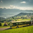
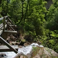
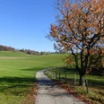
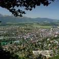
From the Steffisburg/Post bus stop just a few steps to the bank of the Zulg. Upstream to the first bridge, where you keep a little away from the stream. On a wide forest road first at the edge of the forest, then through beautiful mixed forest following the winding course of the Zulg. The silence, only interrupted by the rushing of the water, is refreshing. On the wobbling Waggelisteg you cross the stream and climb steeply on an excellently laid forest path to the Schallenbergstrasse. Along the way, magnificent deep and panoramic views of Steffisburg and the Stockhorn range. On side roads and over field paths you now cross the scenic high plateau via Fahrni, Fuchsegg, Hinderzünen to Schwarzenegg. An overwhelming view towards the valley end of the Eriz with Hohgant, Sigriswilgrat, the Stockhorn range and the snowy peaks of the back Frutigland compensate for the overall long stretch on asphalt. From the Schwarzenegg church you keep the direction for another 300 m, then cross the main road and head south to the Stäg farmstead. From there it goes steeply down the ravine to the Eselsteg and just as steeply up again through the Wüleri forest on the other slope. After leaving the forest, you reach with a gentle ascent the hamlet of Burghalte and continue on agricultural roads to Buchen/Wägli and Lütschetal. The descent on little-travelled roads on the northern flank of the Egg via Enzebüel, Dreiligass, Gappe to Steffisburg offers incomparable views of Churzeberg, Belpberg, the Gurnigel area, and even the Chasseral.

Good to know
Pavements
Best to visit
Directions
Steffisburg - Fahrni - Schwarzenegg - Buchen - Steffisburg
Equipment
We recommend the following equipment: lightweight trekking shoes, light backpack, sun protection, rain jacket, pocket pharmacy, light picnic, enough fluids, mobile phone.
Directions & Parking facilities
Outbound and return journey: by train to Thun and further by bus to Steffisburg, stop Platz
Additional information
Berner Wanderwege association, Bern, Tel.: 031 340 01 01, E-mail: info@beww.ch, Homepage: www.bernerwanderwege.ch
Literature
Hiking suggestion from the hiking book Thunersee - Frutigland, hiking book series of the Berner Wanderwege.
License (master data)
Safety guidelines
This route runs exclusively on signposted paths of the hiking trail category.
Map
Swisstopo hiking map 1:50,000 253T Gantrisch
Nearby


