
- 2:40 h
- 6.77 km
- 5 m
- 1,451 m
- 896 m
- 2,346 m
- 1,450 m
- Start: Burglauenen, Berghaus Männdlenen
- Destination: Burglauenen, Station der Berner Oberland-Bahn
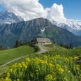
There is a steep but scenic trail descending from Berghaus Männdlenen into the valley of the Schwarze (black) Lütschine: the route ends at the Burglauenen stop of the Berner Oberland Railway. The descent route is also recommended, in the event that you are running a bit late on the path from First to the Schynigen Platte.

Berner Wanderwege
Good to know
Best to visit
suitable
Depends on weather
Directions
Berghaus Männdlenen - Oberläger - Unterläger - Schärmatta - Burglauenen
Equipment
Normal hiking gear, hiking boots with good soles.
Additional information
Wanderung 64
(in der gedruckten Sommer Panoramakarte der Jungfraubahnen)
License (master data)
Safety guidelines
Mountain hiking trail.
Nearby

")