
- 3:00 h
- 43.38 km
- 1,023 m
- 1,021 m
- 563 m
- 1,202 m
- 639 m
- Start: Steffisburg, station
- Destination: Interlaken, east station
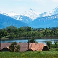
Starting from Thun station, the route leads towards Steffisburg. You will already have to accept the first drops of sweat during the ascent to Goldiwil. But the first hardships are quickly forgotten because the unique panorama of Lake Thun, the pyramid-shaped Niesen, and the proud four-thousand-meter peaks is overwhelming. This is followed by ups and downs through flower meadows past Ringoldswil and Heiligenschwendi to Sigriswil. From Sigriswil, another steep ascent follows. The route is partly almost alpine; far from noise, you can enjoy the impressive natural scenery of the Justistal. All roads are paved and therefore easy to ride. The sunny terrace village of Beatenberg is another highlight of the route. After a downhill ride, you reach the tranquil Unterseen, pass through the picturesque old town there, and cross a bridge over the Aare to the Höhematte. Here you can enjoy the view of the famous massif of Eiger, Mönch, and Jungfrau.

Good to know
Pavements
Best to visit
Directions
Additional information
The information on duration, fitness, and technique depends on the chosen type of bike (mountain bike, e-bike, e-mountain bike, touring bike, racing bike). These are average reference values.
Interlaken Tourism
Marktgasse 1
CH-3800 Interlaken
T +41 33 826 53 00
mail@interlakentourism.ch
www.interlaken.ch
Thun-Lake Thun Tourism
Seestrasse 2
CH-3600 Thun
T +41 33 225 90 00
thun@thunersee.ch
www.thunersee.ch
License (master data)
Nearby


")
")
")