


- 4:40 h
- 9.74 km
- 800 m
- 800 m
- 1,596 m
- 2,137 m
- 541 m
- Start: Chrindi
- Destination: Chrindi
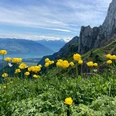
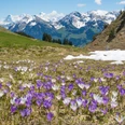
The hike begins at the mid-station of the Erlenbach–Stockhorn aerial cableway, in Chrindi. Just behind the mountain restaurant (magnificent view from its terrace!) the circular path around the Hinterstocken Lake gently ascends and crosses, partly even through a tunnel, the northern flank of the Mieschflue. Impressive are the deep views over the green-blue mountain lake, where fishermen abound on its shores. The well-secured path slowly descends to the houses of Hinterstocken. At a sharp angle, the circular route is left and, always keeping direction, you leisurely ascend first through forest, then through a flower-rich meadow hollow towards Oberstocken Lake. A short right turn leads to the signpost at point 1770 at Oberstocken (via the Strüssligrat to the Stockhorn 1h15, caution!). To the west one sees the Oberstocken Lake lying some 100 m lower in a large basin. The herders also call it Speetbärgli Lake, as ice and snow often remain until far into spring. Like the Hinterstocken Lake it has no visible outflow. Dye tests have clearly shown that it drains to the Buuschebach.
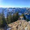
With slight ups and downs, above Wandels hut you turn into the so-called “Bättelwägli” and reach along the slope, finally steeply rising, the alpine hut Oberi Walalp. Here begins the actual ascent to the Stockhorn. Over a pasture path with only moderate incline you reach Baachegg. Wonderful view into the lower Thun lake basin. The west face of the Stockhorn towers mightily above you. A conquest seems almost impossible. On a good path, partly over steps, it goes very steeply upwards, directly to the base of the Stockhorn wall. Above the rock heads of the Strüssligrat you keep left and reach via the promenade paragliders’ ramp, mountain station, panorama restaurant, and in a few minutes the summit of the Stockhorn.
The descent is easy to follow, the goal, the blue-green eye of the Hinterstocken Lake, already shines from below. Immediately after passing under the cable car cables, a variant is offered (to Oberbärgli–Chrindi 1h). More varied is the descent over the Oberstocken alp and through magnificent mountain forest to the Hinterstocken Lake. You bypass this lake eastwards and finally reach the starting point of the magnificent mountain hike in Chrindi with a slight ascent.

Good to know
Pavements
Best to visit
Directions
Equipment
Directions & Parking facilities
Additional information
Literature
License (master data)
Safety guidelines
This route runs entirely or partially on marked trails of the mountain hiking path category
Map
Nearby
")
")
")