

- 6:00 h
- 13.48 km
- 1,346 m
- 952 m
- 573 m
- 1,919 m
- 1,346 m
- Start: Oberried
- Destination: Kemmeriboden Bad
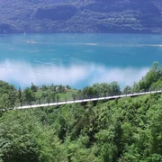
From Oberried station, first head a little below the main road eastwards. Then turn towards the slope through the underpass to the church and immediately climb steeply to the forest edge at Hirscherenbach. Where this stream emerges from a narrow ravine, a wide debris cone has formed. From here, you overlook Lake Brienz almost along its entire length. The mostly dried-up Hirscherengraben is crossed on a forest road. The path now leads into the magnificent beech forest. From the first forest clearing, the view opens towards the lake with Iseltwald and the mountains above the extensive Bättenalp in the Faulhorn area. In several bends, the wide, well-made toboggan run gains altitude. At a bend outside the forest stands a hut where hay bales were brought to safety in the mountain hay during thunderstorms. Through another forest patch, you reach the forest edge and step onto the slope meadows below the Riedergrat. The deep view onto the lake is superb. The path becomes a trail, and the steepness of the terrain even increases. Only from Bitschi onwards is there a slightly gentler stretch for recovery.
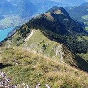
After another rather steep climb, the Ällgäulücke, the ridge crossing to Kemmeribodenbad, is reached. Not only is the view of Brienzer Rothorn, Titlis, and the Susten area captivating; equally compelling is the outlook to Faulhorn, Gärstehorn, Wildgärst, Axalp, and the Bernese high Alps towering behind. Far below lie Meiringen and Lake Brienz. To the north, Hohgant, the bright Schrattenflue with the distinctive Schibengütsch, and the Kemmeriboden gorge dominate the horizon.
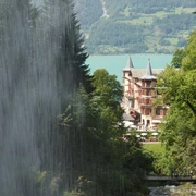
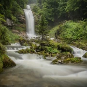
Now across alpine pastures, leaving the huts of Ober Läger on the left, onto the driveable road that leads down to Alp Ällgäuli. Through forest and over a marshy slope hollow, you reach Mirrenegg, from where an alpine lane leads down to the young Emme. At Hinter Hübeli, the lane crosses to the left side of the Emme. The young river rages here like a torrent. The debris cones of the tributary streams hint at how dangerous the water swells after thunderstorms. Pleasant, by contrast, is the cozy comfort radiated by the hospitable Kemmeribodenbad with its mighty roofs.

Good to know
Pavements
Best to visit
Directions
Oberried - Bitschi - Ällgäulücke - Mirrenegg - Kemmeriboden Bad
Equipment
We recommend the following equipment: sturdy mountain boots, medium-sized backpack with hip belt, sun protection, rainwear, hiking poles, pocket first aid kit, picnic, sufficient fluids, mobile phone.
Additional information
Bernese Footpaths Association, Bern, Tel.: 031 340 01 01, Email: info@beww.ch, Homepage: www.bernerwanderwege.ch
Literature
Hiking suggestion from the Jungfrau Region Brienz Lake - Oberhasli hiking book, hiking book series of the Bernese footpaths
License (master data)
Safety guidelines
This route runs entirely or partly on marked paths of the mountain hiking trail category.
Map
Swisstopo hiking map 1:50,000 254T Interlaken
Nearby
")