- 4:20 h
- 10.72 km
- 800 m
- 800 m
- 1,170 m
- 1,915 m
- 745 m
- Start: Kandersteg
- Destination: Kandersteg
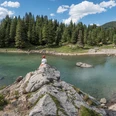
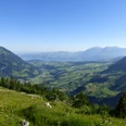
From Kandersteg train station, follow the BLS line upstream along the valley. Just before reaching Dorfstrasse, at Rain stands the magnificently preserved Ruedihus dating from 1853. One cannot cease to marvel when viewing the facade rich with inscriptions and ornaments with cozy, lead-framed, circular stained-glass windows. Then proceed to Hotel Doldenhorn at the forest edge and before it turn right into the woods. The ascent begins immediately. The path winds through the forest in many switchbacks up to point 1435 in Dürrenschwand (following the Schleife–Fisialp–Doldenhornhütte SAC loop takes 2 hours; only for absolutely sure-footed, confident mountain hikers as the path is very exposed in the early stretches at Obere Biberg). The trail now undulates gently through the mountain forest to Undere Biberg. Along the stream, with a steep climb, another steep section must be overcome before the path on Obere Biberg joins the alpine trail from Fisialp. About 100 meters of elevation still remain to reach the Doldenhornhütte SAC, where a lengthy rest is recommended, as the hut stands on a ridge offering fascinating panoramic views: the left side of the Kandertal is bordered by Bunderspitz, First, Stand, Chilchhore, and Elsighorn. Bire, Zallershorn, Dündenhorn, Bundstock, and Schwarzhorn form the opposite mountain range. Over the nearby Lake Oeschinen rise the walls, glaciers, and firn of the Blüemlisalp, while behind the Fisistöcke mighty rock masses must have tumbled down in prehistoric times. What a fascinating mountain world!
For the descent to Kandersteg, follow the ascent route back to Undere Biberg, then turn right crossing the stream towards the cliff ledges. Caution when entering the so-called Bäretritt, which leads very steeply down into Öschiwald (40 minutes to Lake Oeschinen, 1 hour 10 minutes to the chairlift top station). The path leads through beautiful mountain forest directly back to the center of Kandersteg and to the train station.

Good to know
Pavements
Best to visit
Directions
Kandersteg - Biberg - Doldenhornhütte SAC - Öschiwald - Kandersteg
Equipment
We recommend the following equipment: sturdy mountain boots, medium-sized backpack with hip belt, sun protection, rainwear, hiking poles, pocket first aid kit, picnic, sufficient fluids, mobile phone.
Directions & Parking facilities
Various parking lots in Kandersteg
Outbound and return travel: by train to Kandersteg
Additional information
Association Berner Wanderwege, Bern, Tel.: 031 340 01 01, Email: info@beww.ch, Homepage: www.bernerwanderwege.ch
Literature
Hiking suggestion from the Berner Oberland hiking book, Berner Wanderwege hiking series
License (master data)
Safety guidelines
This route runs wholly or partly on marked paths of the mountain hiking trail category.
Map
Swisstopo hiking map 1:50,000 263T Wildstrubel
Nearby