- 3:00 h
- 7.76 km
- 339 m
- 340 m
- 1,597 m
- 1,892 m
- 295 m
- Start: Grimsel Pass/Chüenzentennlen
- Destination: Gelmersee (circular route)
From the post bus stop Chüenzentennlen above Handegg, the path initially ascends gently between berry bushes and over wet meadows, then somewhat steeper through rocky terrain. There are beautiful views down into the valley of the young Aare and the opposite side valleys. The ascent to Gelmersee does not involve major exertion.
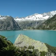
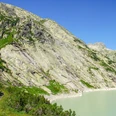
The circular route around the reservoir is laid out as a mountain hiking trail. Along the southern shore, the route initially follows mostly level paths heading east, then a short ascent follows and subsequently a descent again. The lake lies in a valley whose side walls are quite steep. Therefore, the path often runs only as a narrow path over steep rock slabs along the water. In exposed spots, steel cables provide support.
There are opportunities to rest, for example, on the east shore where the Alplibach flows into a flat mountain meadow with scattered rock blocks, as well as near the location Undrists Diechter around the Diechterbach. There is also a junction there from which a mountain trail leads up to the Gelmer hut (ascent 1 h 35).
The Gelmersee circular route continues to the northern end of the dam. Here is located the mountain station of the Gelmerbahn. Recently, the originally power station-operated, extraordinarily steep funicular railway has also been opened to the public. Those to whom such a downhill ride feels too spectacular and breathtaking can cross the dam and return on foot to Chüenzentennlen.

Good to know
Pavements
Best to visit
Directions
Grimsel Pass/Chüenzentennlen - Gelmersee - Undrist Diechter - Gelmersee (circular route)
Equipment
We recommend the following equipment: sturdy mountain boots, medium-sized backpack with hip belt, sun protection, rainwear, hiking poles, first aid kit, picnic, sufficient fluids, mobile phone.
Directions & Parking facilities
Outbound and return journey: by private car or bus from Innertkirchen to the stop Handegg, Kunzentännlein
Additional information
Association of Bern Hiking Trails, Bern, Tel.: 031 340 01 01, E-Mail: info@beww.ch, Homepage: www.bernerwanderwege.ch
License (master data)
Author´s Tip / Recommendation of the author
We recommend for overnight stay or a meal: Hotel Grimsel Passhöhe, www.hotel-grimselpass.ch, info@hotel-grimselpass.ch, T. 033 973 11 37
Safety guidelines
This route runs entirely or partly on mountain hiking trails. Freedom from dizziness is required!
Map
Swisstopo hiking map 1:50,000 255T Susten Pass
Nearby