

- 3:00 h
- 8.87 km
- 350 m
- 700 m
- 1,796 m
- 2,404 m
- 608 m
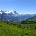
- Start: Grindelwald/First
- Destination: Bussalp
From the upper station First of the gondola, you hike along the well-travelled Faulhorn route to the Bachalpsee (from Bachläger – First 1h15). Along the way, you have a magnificent view of the Grindelwald mountains. Particularly beautiful is the reflection of the white mountain giants in the mountain lake. Before the larger lake, turn left uphill and ascend to the ridge, which extends from Uf Spitzen to the Reeti. Overwhelming is the view to the crown of the high Alpine peaks at the ridge height (from Fleesch–Waldspitz–First 1h45).
Over the ridge, you climb almost 100 m to the highest point of the hike before the path swings into the southern flank of the Reeti and descends through rockfall debris to the Alp Holzmatten. Then, you cross the wide basin of the Büössalp and descend rather steeply over Oberläger to the bus turning area at Bussalp/Mittelläger. To the west rises the Burg, the remnants of a limestone rock that collapsed into the valley and formed today’s valley step of Burglauenen.

Good to know
Pavements
Best to visit
Directions
Equipment
Additional information
Literature
License (master data)
Safety guidelines
This route runs entirely or partially on marked paths of the mountain hiking trail category
Map
Nearby


")