


- 5:00 h
- 9.78 km
- 1,757 m
- 59 m
- 567 m
- 2,266 m
- 1,699 m
- Start: Brienz, Railway Station West
- Destination: Rothorn Kulm
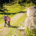
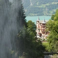
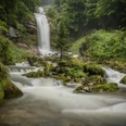
Steep in parts, this route leads alongside the Milibach Falls up to Planalp, from where you can marvel at stunning views. The hike continues up across fields and meadows far above the treeline to the Brienzer Rothorn ridge.
Current diversion:
As the Milibach stream triggered a major debris flow in August 2024, the hiking trail along the stream to the waterfall is closed until further notice. The detour leads from Brienz along the Trachtbach stream via the hiking trail towards «Gäldried» to Planalp.
Looking for more hiking choices?
Here you will find details of hiking trails to inspire you in the Bernese Oberland.

Good to know
Pavements
Best to visit
Directions
Equipment
Directions & Parking facilities
Additional information
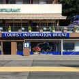
Hauptstrasse 143
3855 Brienz
Phone: +41 33 952 80 80
info@brienz-tourismus.ch
www.brienz-tourismus.ch
Interlaken Tourism
Marktgasse 1
3800 Interlaken
Phone: +41 33 826 53 00
mail@interlakentourism.ch
www.interlaken.ch
Brienz Rothorn Railway: www.brb.ch
Berghaus Planalp: www.berghaus-planalp.ch
License (master data)

Author´s Tip / Recommendation of the author
Safety guidelines
Nearby


")
")
