


- 1:20 h
- 3.71 km
- 8 m
- 300 m
- 1,133 m
- 1,407 m
- 274 m
- Start: Kiental, Griesalp stop
- Destination: Kiental, Alpenruhe stop
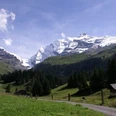
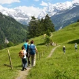
The Gamchi Glacier, at the end of the Kiental between Blüemlisalp and Gspaltenhorn, is the source of the Gornerewasser, which first rushes as the Gamchibach through the Gamchi and via Bundstäg to the Griesalp. On the following 250 meters in elevation down to the Tschingelsee, the Gornerewasser becomes a rough, winding mountain stream. Its bed winds through rock blocks, disappears in underground tunnels, and then shoots splashing through openings towards the valley. Waterfalls like the Pochtenfall and water basins like the Hexenkessel make the hike from Griesalp to the Tschingelsee both impressive and varied. The rushing of the stream stops abruptly at the bottom, and the mountain stream, which has become a broad body of water, calmly spreads out on the alluvial plain of the Tschingel. Not much is left of the former lake. Instead, a unique nature reserve has formed here, continually changing its appearance. At the end of the alluvial plain, the Gornerewasser bundles and flows as the Chiene towards the Kandertal. Those who like can follow it further to Kiental Dorf or end the hike as described here at the Restaurant Alpenruhe.

Good to know
Pavements
Best to visit
Directions
Griesalp - Pochtenalp - Pochtenfall - Hexenkessel - Tschingel - Tschingelsee - Bir Alperue
Equipment
We recommend the following equipment: lightweight trekking shoes, light backpack, sun protection, rain jacket, pocket pharmacy, light picnic, sufficient fluids, mobile phone.
Directions & Parking facilities
By car via Reichenbach into the Kiental. Parking lots at the valley station of the Ramslauenen railway. Then by bus from the Kiental Dorf stop to Griesalp.
Parking lots; valley station Ramslauenen, Loosplattenalp, Tschingel (all chargeable)
Outbound: by train to Reichenbach in the Kandertal. Then by bus to Kiental to the Griesalp stop
Return: from Kiental/Alpenruhe by bus to Reichenbach.
Additional information
Bern Hiking Association, Bern, Tel.: 031 340 01 01, Email: info@beww.ch, Homepage: www.bernerwanderwege.ch
Literature
Hiking suggestion from the free brochure Hiking by the Water, by Berner Wanderwege.
License (master data)
Safety guidelines
This route runs exclusively on signposted paths of the hiking trail category. Attention: wet boardwalks, bridges, and rock slabs are partly slippery!
Map
Swisstopo hiking map 254T Interlaken and 264T Jungfrau 1:50,000
Nearby