- 3:30 h
- 10.60 km
- 440 m
- 510 m
- 1,805 m
- 2,079 m
- 274 m
- Start: Adelboden, Sillerenbühl
- Destination: Adelboden, Höchsthore
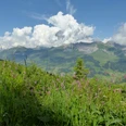
At the starting point of the hike at the mountain station of the gondola lift on the Silleren, follow the route to Hahnenmoospass. This section is marked as a hiking trail. Small signs provide explanations about the plants growing here, hence the designation as a flower trail. A short downhill stretch on a forest road is followed by a path. This first runs along the ridge, then in slope position below the Lavey ridge. Initially uphill and then downhill, you reach the Hahnenmoospass. The pass crossing is a notable hub of the ski areas of Adelboden and Lenk in winter. In summer, the area around the pass is a mecca for model sailplane flyers. Now follow the signpost indication for Chuenisbärgli. A gently ascending alpine path, then a trail past Rägeboldshore, leads to the highest point of the hike at Luegli. From here you can see Adelboden, the Niederhorn and the Sigriswilergrat with the Sichle pass crossing in between.
It follows a steep descent through scree and over alpine pastures. According to tradition, this is the homeland of the Adelboden Vogellisi, celebrated in a folk song. After a flat intermediate section on a forest road, the ascent continues from Bütschi over alpine pastures to the Troneg ridge. A newly created path leads to the mountain station of the Höchsthore chairlift, the destination of the hike (from here, Adelboden can be reached on foot in 1 hour and 20 minutes). On the right, the Lohner group and the Entschligefälle present themselves. Fritz Brönnimann

Good to know
Pavements
Best to visit
Directions
Equipment
Directions & Parking facilities
Additional information
Literature
Hiking book Panoramic hikes of the Berner Wanderwege
License (master data)
Safety guidelines
Map
Swisstopo hiking map 1:50,000 263T Wildstrubel
Nearby