- 2:20 h
- 7.45 km
- 370 m
- 370 m
- 998 m
- 1,323 m
- 325 m
- Start: Innereriz
- Destination: Innereriz
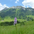
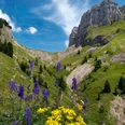
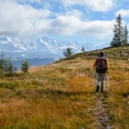
The Eriz is a quiet valley with charming landscapes and a wide range of hiking options. Additionally, it lies away from tourist crowds and is well accessible by public transport from Thun. This circular route offers a magnificent panorama and lots of nature despite its relative brevity. The start is at Innereriz Säge. At the eponymous restaurant, the path leads over a farm access road upwards towards Scheidzaun and Rotmoos. After crossing the Chaltbach ravine, you find yourself at the edge of the Rotmoos high moor, a nationally significant nature reserve with a large number of rare plants and bird species. Here, hikers responsibly stay on the marked path to protect the sensitive vegetation; the path leads through a bright forest of enchanting appearance. At the huts of Unter Scheidzaun, the path turns west. It continues upwards over alpine pastures and mountain forest before descending towards Babschwand and the Eriz valley. On a pretty hiking trail along the Zulg, you return to the starting point with opportunities to stop for refreshments. The broad and almost entirely forested ridge of the Honegg separates the Eriz from Oberemmental and provides a beautiful end to the valley. On this broad mountain ridge is one of the largest contiguous forest areas in the canton of Bern. The gaps torn open by the storm winds of cyclone Lothar are slowly growing over again. In the Zugschwand area, a mighty sycamore maple could be admired for many years. The several hundred-year-old Bürkeli maple, once protected as a natural monument, has now decayed. The easy hike does not lack magnificent views: the mighty cliff faces of the Hohgant rise impressively, the rock formation of the Sibe Hängste looks unusual, and the Sichle between the Sigriswilergrat and the Burst is beautifully presented.

Good to know
Pavements
Best to visit
Directions
Directions & Parking facilities
License (master data)
Map
swisstopo hiking maps 244T Escholzmatt and 254T Interlaken
Nearby