- 5:35 h
- 17.46 km
- 1,000 m
- 727 m
- 775 m
- 1,234 m
- 459 m
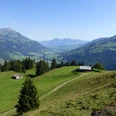
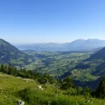
- Start: Frutigen
- Destination: Kandersteg

Berner Wanderwege
Good to know
Pavements
Trail
Asphalt
Street
Path
Best to visit
suitable
Depends on weather
Directions
Frutigen - Tellenburg ruin - Kandergrund - Mitholz - Felsenburg ruin - Büel - Kandersteg
Equipment
We recommend the following equipment: light trekking shoes, light backpack, sun protection, rain jacket, pocket first aid kit, light picnic, sufficient fluids.
Directions & Parking facilities
Arrival by train to Frutigen
Return by train from Kandersteg
Additional information
BLS AG, www.bls.ch/bahnwanderweg
License (master data)
Safety guidelines
This route runs exclusively on marked paths of the hiking trail category
Map
Swisstopo hiking map 1:50,000, 253T Gantrisch and 263T Wildstrubel, order at: http://shop.bernerwanderwege.ch
Nearby