- 3:45 h
- 8.87 km
- 730 m
- 650 m
- 1,829 m
- 2,466 m
- 637 m
- Start: Hasliberg/Käserstatt
- Destination: Melchsee-Frutt
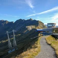
The alpine view from the end station of the chairlift is incomparable. A similarly extensive alpine area is hard to find: Mägisalp, Seemad, Gummen, Balisalp, Talalp, and Melchtalalp form a contiguous huge alpine area all around. Over the ridge of the Hohsträss, the mountain path swings around the upper edge of the Melchen alpine pasture towards Wit Ris on the Hochstollen ridge. On good rock steps (caution is still advised), it now heads steeply up to Hochstollen.
Magnificent panoramic view: the tangle of ridges and valleys in between appears harmonious despite everything. In a straight line lie Melch, Tannen, and Engstlensee lakes. Countless horns and peaks limit the horizon. Just below the ridge edge, the path now descends steeply to Abgschütz. Shortly before this, a rocky steep drop requires utmost caution! At the saddle, the path turns right and falls very steeply through a scree field downhill. The conclusion is gentle past Blausee towards Melchsee-Frutt, which lies high in a wide alpine basin above the Melch valley.

Good to know
Pavements
Best to visit
Directions
Equipment
We recommend the following equipment: sturdy mountain boots, medium-sized backpack with hip belt, sun protection, rainwear, hiking poles, pocket pharmacy, picnic, sufficient fluids, mobile phone.
Directions & Parking facilities
Outbound: By train to Brünig Pass height, from there by bus to Hasliberg, Twing. By gondola lift up to Käserstatt mountain station.
Return: From Melchsee Frutt by cable car
Additional information
Literature
Hiking suggestion from the hiking book Jungfrau Region Brienzersee - Oberhasli, hiking book series of the Bernese Hiking Trails
License (master data)
Safety guidelines
Map
Swisstopo hiking map 1:50,000 255T Sustenpass
Nearby