


- 5:00 h
- 14.13 km
- 880 m
- 1,100 m
- 867 m
- 1,874 m
- 1,007 m
- Start: Kaltenbrunnensäge
- Destination: Zwirgi
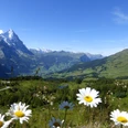
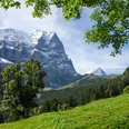
From the Kaltenbrunnensäge bus stop, we first cross the Reichenbach and ascend on an alpine road – initially with a wonderful view of the steeply rising Wellhorn, flanked by the Rosenlaui Glacier and Wetterhorn – up to the Obre Stafel alp (1662 m). On a meadow path, continue briefly until you branch right onto a hiking trail, where an information board about the upcoming Chaltenbrunnen nature reserve with its raised bog is located. Through increasingly sparse flora, we walk along numerous streams and ponds, ascending gently with good views. At an unremarkable mountain pass (unnamed and unmarked on the national map), a path branches off on the right, leading in 5 minutes to the flat summit of Gyresprung (1887 m) – a worthwhile detour as you enjoy a beautiful panoramic view from the Wandelalp with the prominent Garzen tooth above it, all the way to Lake Brienz, Lake Lungern and the Haslital valley.
You quickly descend to the alpine huts at Im Obersten Wandel. In the further descent over the Im Mittlesten Wandel alp, alpine roads and hiking trails alternate with forest and meadows – often accompanied by the rushing Wandelbach, which is left only after the fourth crossing at Mettlen. From here, it continues more gently westward, first over meadowland (yellow marked from Isetwald), then on a farm road and again on a hiking trail (don't miss the junction at P.985) to Falcheren. From here via Louenen to Zwirgi, the hiking trail rises again slightly. Along the way, you have the option to branch off to the Reichenbach railway or to continue hiking down to Willigen/Meiringen. At the endpoint at Zwirgi, a nice sunny terrace awaits for a well-deserved break.

Good to know
Pavements
Best to visit
Equipment
Directions & Parking facilities
Arrival: by bus from Meiringen train station towards Rosenlaui, stop Kaltenbrunnensäge
Return: by bus from the Zwirgi stop to Meiringen train station
Additional information
Literature
Hiking book Bernese Oberland by the Bernese Hiking Trails
License (master data)
Safety guidelines
Map
Swisstopo hiking map 255T Sustenpass 1:50,000
Nearby

