- 3:30 h
- 8.41 km
- 780 m
- 334 m
- 1,615 m
- 2,346 m
- 731 m
- Start: Grindelwald/Alpiglen
- Destination: Grindelwald/Kleine Scheidegg
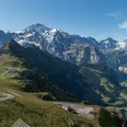
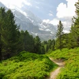
From the small Alpiglen station, head briefly downstream. At the mountain restaurant, the excellently laid out mountain hiking trail branches off in the direction of the Mittellegi ridge and winds very steeply in a zigzag over alpine pastures and through larch forest upwards. A stream deeply incised into the limestone rock is crossed on firmly anchored bridges. A first rest stop is worthwhile at a hairpin bend on the path, as the ice water from the Eiger shoots out powerfully from a rock channel here. As a long, constantly steeply rising traverse along the slope, the path leads over the Langenegggraben along the foot of the Eiger North Face into the valley landscape Im glatten Wang. Impressive are the upward and downward views of the imposing climbing wall, Kleine Scheidegg, and the green Grindelwald valley. Over colorful alpine flower carpets and bare limestone slopes, through snow grooves and scree fields, you reach the Wart viewpoint. Occasionally, climbers in the wall can be observed with binoculars: 150 to 200 climb it each year. During the same period, 3 to 9 people have to be airlifted from the wall. The view into the glacier world from the Eigergletscher station is indescribable. The husky breeding stationed here also supplies the sled dogs at Jungfraujoch.
The descent to Kleine Scheidegg closely follows the route of the Jungfrau Railway.

Good to know
Pavements
Best to visit
Directions
Equipment
Additional information
Literature
Hiking suggestion from the hiking book Jungfrau Region Brienzersee - Oberhasli, hiking book series of the Bernese Hiking Trails
License (master data)
Safety guidelines
This route runs entirely or partly on marked trails of the mountain hiking trail category
Map
Swisstopo hiking map 1:50,000 254T Interlaken
Nearby