- 5:30 h
- 15.12 km
- 880 m
- 880 m
- 1,385 m
- 1,949 m
- 564 m
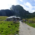
- Start: Untere Gantrischhütte
- Destination: Untere Gantrischhütte
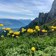
The healing spring of Schwefelbergbad has been historically known since the 16th century. From the hotel, one of the last witnesses to Bernese spa culture, follow briefly the Schwefelberg road built in 1925, then turn onto the old alpine trail which leads up the northern slope of the Birehubel to the Ritzhütte. Over the foaming Gantrisch-Sense, one crosses to the Untere Gantrischhütte. Fir-forested pastures surround the lake surface of the Gantrischseeli, at which point you ascend to the Obere Gantrischhütte. Now continue on the mountain pass trail, which was newly laid out by troops during the last active military service period (1939–45). Always climbing steeper, it winds from the Chummlihütte up to the pass height of Morgetegrat. The view here is magnificent: the horizon is bounded by Balmhorn, Wildstrubel, Wildhorn, and Les Diablerets. Below, you look toward the green hills of the Simmental.
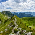
On the Simmental side, it goes very steeply down to the herders' huts of Obrist- and Mittlist Morgete (to Undrist Morgete–Weissenburg 2h30). The path then almost levels out near the treeline to the alpine hut Sunnig Ripprächten. Between large rock debris, one then climbs to the Schattigseeli, in which the rock mounds of Alpiglemären are reflected (to Lochegg–Oberwil 2h10). In a few minutes, the pass height of Grenchegalm is reached. Beautiful view back over the alpine basin to the Stockhorn (to the Widdersgrind viewpoint 40 min, caution!). Impressive deep view into the Hengstschlund to the alpine pastures Grencheberg and Seeberg. On a narrow path, it now goes over pasture and through wooded rockfall area, then very steeply down to the Frilismad hut. On almost flat path, the trail turns into the large alpine basin of Ober Alpigle. The sheer cliff walls of Alpiglemären and Ochsen rise steeply over the herders' hut. Through forest tongues, grassy gulches, and rockfall areas, the trail passes the Ritz hut through the steeply sloping flank of the Louigrat down into the valley of the Gantrisch-Sense and back to the Schwefelbergbad.

Good to know
Pavements
Best to visit
Directions
Equipment
Directions & Parking facilities
Additional information
Literature
Hiking suggestion from the hiking book Region Bern - Gantrisch, hiking book series by BWW
License (master data)
Safety guidelines
This route runs wholly or partly on signposted paths of the mountain hiking trail category
Map
Swisstopo hiking map 1:50,000 253T Gantrisch
Nearby