- 3:45 h
- 12.32 km
- 401 m
- 332 m
- 945 m
- 1,221 m
- 276 m
- Start: Kiental
- Destination: Aeschiried
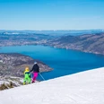
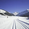
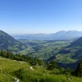
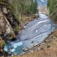
In Kiental, leave the bus stop downhill and ascend, sometimes on the alpine road, sometimes via shortcuts, to the houses of Hubel. Enjoyable is the subsequent walk through blooming meadows. Looking back, you see the sunlit snowfields of the Blüemlisalp. With slight ups and downs, you go to the large Härggis-Allmi dairy, from where the view opens up to the toy-like houses in the Kandertal and the Niesen mountain range. Through the Haasele forest, you cross over the Richebach-Graben and soon descend on a unfortunately paved road to Faltsche. Via Weeggers, you now proceed almost level into the Suld valley. On the Suldweid, you cross the stream and enjoy the lush vegetation (nature reserve) while hiking downhill. After a short ascent to the valley road, the Aeschiried viewing platform is soon reached, offering a magnificent panoramic view of Lake Thun.

Good to know
Pavements
Best to visit
Directions
Kiental - Faltsche - Aeschiried
Equipment
We recommend the following equipment: light trekking shoes, light backpack, sun protection, rain jacket, pocket first aid kit, light picnic, sufficient fluids, mobile phone.
Additional information
Association Bernese Hiking Trails, Bern, Tel.: 031 340 01 01, E-Mail: info@beww.ch, Website: www.bernerwanderwege.ch
Literature
Hiking suggestion from the hiking book Thunersee - Frutigland, hiking book series by the Bernese hiking trails
License (master data)
Author´s Tip / Recommendation of the author
Continue hiking via the suspension bridge Leissigen - Meielisalp - Därligen
Safety guidelines
This route runs entirely on hiking paths.
Map
Swisstopo hiking map 1:50,000 254T Interlaken
Nearby