- 2:20 h
- 7.30 km
- 370 m
- 370 m
- 998 m
- 1,323 m
- 325 m
- Start: Innereriz
- Destination: Innereriz
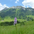
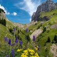
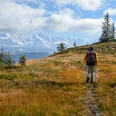
The broad and almost completely forested ridge of the Honegg separates the Eriz from the Oberemmental and ensures that this uppermost part of the Zulg valley forms an independent, topographically largely enclosed terrain chamber. Around 1320, the region was first mentioned in documents – referred to as “im Eraza”, which is said to have originated from “Erharts” (property of Erhart). From Inneriz/Säge you reach the Dräcker farmhouse on a paved farm access road. Continuing to gently ascend, you cross a short forest area and immediately afterwards a large clearing. After crossing the Chaltbach ditch, you continue to ascend along the reddish shimmering high moor of Rotmoos. The approximately 65 ha nature reserve Rotmoos-Breitwang has been protected since 1944. 122 rare plant species (strictly no picking allowed!) and 62 bird species have been observed here. The extraordinarily sensitive vegetation allows entry only on specially constructed paths. At the huts of Unter Scheidzun, you turn west and, still gently ascending, reach the Chaltbach again. Over alpine pastures and through mountain forest you reach Babschwand, from where the path descends to the Bödeli. On the way, magnificent views of the cliff faces of Hohgant, Solflue and Sigriswilgrat with the striking notch of the Sichle in between. Below the main road, there is a charming hiking trail along the Zulg. On this you ascend back to the starting point Innereriz/Säge.

Good to know
Pavements
Best to visit
Directions
Innereriz - Unter Scheidzun - Babschwand - Innereriz
Equipment
We recommend the following equipment: light trekking shoes, light backpack, sun protection, rain jacket, first aid kit, light picnic, sufficient fluids, mobile phone.
Directions & Parking facilities
Outbound journey: by bus from Thun to Innereriz/Säge
Return journey: by bus from Innereriz/Säge
Additional information
Berner Wanderwege, T 031 340 01 01, info@beww.ch, bernerwanderwege.ch
Literature
License (master data)
Author´s Tip / Recommendation of the author
Safety guidelines
This route runs exclusively on hiking trails.
Map
Nearby