


- 6:00 h
- 17.77 km
- 800 m
- 1,200 m
- 1,009 m
- 2,047 m
- 1,038 m
- Start: Jaunpass
- Destination: Saanen
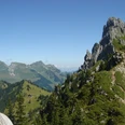
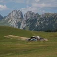
From Jaunpass heading south to the alpine huts on the Oberenegg Läger high terrace. The path now bypasses the northern spur of the Hundsrügg and leads over the pasture ridge up to the lonely Hürli hut. Even from here you can enjoy a magnificent panoramic view. Now begins the easy and enjoyable ridge hike along the elongated ridge. The alpine flora along the way is delightfully diverse. Since the mountain ridge is treeless, from the highest point of the Hundsrügg you enjoy an incomparable view: At the western foot of the mountain lies the Abländschen valley, above which rise the steep rock pinnacles of the Gastlosen, the Sattelspitzen, and their continuation to Dent de Ruth. The peaks of the Fribourg, Vaud, and Bernese Alps adjoin. Passing the Birehubel on the descent you reach the Bire hut (to Abländschen 1h25; to Saanenmöser 1h20; to Schönried 1h25). Now you cross the slope of the Schneit ridge and gain the ridge again at the Vorderi Schneit hut near point 1769. You also bypass the Planihubel on its west flank and reach the fork of the hiking trail at point 1812 (to Saanenmöser 1h10; to Schönried 1h15). It is still necessary to ascend about 100 meters over the Hugeligrat. What a beautiful view into the Saanenland! After a pleasant ridge walk you reach the mountain station and mountain house on the Rellerligrat (to Schönried 1h25), where besides a wonderful view, a sledding run and a kart track await those hungry for adventure. The descent via Rittmal is pleasant, where in the Middle Ages a “Chutz” (a watchtower) received fire signals from the Flüeweid above St. Stephan and passed them on via Rougemont and Château-d’Œx to Gspan and to the scenic Rote Egg. Via Underbort you reach Saanen with its remarkable church on the historic Mauritius hill.

Good to know
Pavements
Best to visit
Directions
Equipment
We recommend the following equipment:
Sturdy mountain boots, medium-sized backpack with hip belt, sun protection, rainwear, hiking poles, first aid kit, picnic, sufficient liquids, mobile phone.
Directions & Parking facilities
Outbound journey: By train to Boltigen station. From there by bus to Jaunpass.
Return journey: By train from Saanen.
Additional information
Literature
License (master data)
Safety guidelines
Map
Nearby
