- 1:40 h
- 5.83 km
- 80 m
- 290 m
- 1,961 m
- 2,166 m
- 205 m
- Start: Grindelwald/First
- Destination: Grindelwald/Grosse Scheidegg
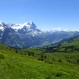
From the First mountain station, there are two variants: via Schreckfeld to Grosse Scheidegg or via Distelboden. While the lower first route follows a wide alpine track, the higher second one often leads only over a path. The route described below is a combination of both routes.
From the final station First of the gondola, you follow a few steps along the Faulhorn path. At the Widderfeld signpost, turn right into the mountain pastures of Alp Grindel and soon reach the scattered alpine huts in Distelboden (to Chrinnenboden–Schwarzhorn 2h25). In a wide arc, cross the basin over the scattered alpine huts of Schreckfeld. The more the path turns southward, the more impressive the view of Eiger, Mättenberg, Schreckhorn and Wetterhorn becomes. Blueberries, heather and dwarf juniper line the path, which is crossed repeatedly by streams. These provide insight into the weathering forms of the shale. The fine black shale chips are partly responsible for the coloring of the water, which gave the valley river the name "Schwarze Lütschine." At the alpine hut settlement Grindel/Oberläger, the upper path can still be taken as far as Gratschärem. Since the lower, wider path allows more freedom of movement, the view of the mighty wall of the Wetterhorn becomes freer. Now the Gutz glacier on the Wetterhorn flank is also clearly visible, from which on September 5, 1996, 220,000 m³ of ice crashed almost vertically down the wall, threatening the Scheidegg road. The ice masses at the bottom were up to 100 m wide and 20 m high. Since then, this glacier is also continuously monitored. In the saddle of the ridge descending from Gemschberg, on Gratschärem, the view to the east is now free: the Rosenlaui valley with its wide alpine pastures and dark forests extends eastward; behind them stand the rugged, jagged walls of the Engelhörner. The Titlis and the Fünffingerstöcke in the Sust region can also be seen. The route continues exactly on the ridge saddle of the Grosse Scheidegg, the watershed which impressively separates the catchment area of the Schwarze Lütschine from that of the Rychenbach and thus the Hasli valley.
At Grosse Scheidegg, you stand at a stage of the Swiss Alpine Pass Route. Even more impressive is the mighty Wetterhorn wall, which rises here almost vertically (Grosse Scheidegg – Wetterhorn = 1400 m elevation difference!).

Good to know
Pavements
Best to visit
Directions
Grindelwald/First - Distelboden - Grindel/Oberläger - Gratschärem - Grindelwald/Grosse Scheidegg
Equipment
We recommend the following equipment: light trekking shoes, light backpack, sun protection, rain jacket, pocket first aid kit, light picnic, sufficient liquids, mobile phone.
Directions & Parking facilities
Paid parking spaces near the valley station Firstbahn or at the Pfingstegg cable car
Arrival: by train to Grindelwald. Then on foot to the valley station of the First cable car. Take the gondola to First.
Return: by PostBus from Grosse Scheidegg to Grindelwald
Additional information
Association Bernese Trails, Bern, Tel.: 031 340 01 01, E-Mail: info@beww.ch, Homepage: www.bernerwanderwege.ch
Literature
Hiking suggestion from the hiking book Jungfrau Region Brienzersee - Oberhasli, hiking book series of the Bernese trails
License (master data)
Safety guidelines
This route runs exclusively on marked paths of the hiking trail category.
Map
Swisstopo hiking map 1:50,000 254T Interlaken
Nearby