- 3:30 h
- 11.49 km
- 59 m
- 1,150 m
- 779 m
- 1,803 m
- 1,024 m
- Start: Elsigenalp, cable car
- Destination: Frutigen, train station
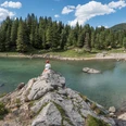
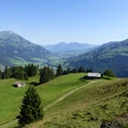
The western flank of Elsighorn is shaped by an almost vertical limestone ridge, regarded as one of the most popular climbing areas in Switzerland. At its foot runs the panoramic mountain hiking path, which starts at the Elsigenalp cable car mountain station. The path runs just below the limestone bands providing an interesting view into climbing routes with names like “Exodus”, “Kummerbuben” or “Turbo”. On a slight descent, the narrow path then leads through forest and alpine pastures to the Upper Achsetberg. Looking up the valley, the panorama opens to the wide valley basin of Adelboden; above it rises the glacier-crowned Wildhorn. On the opposite valley side, the trench landscape of the Niesen range with the Frutig-Spitzen is visible. In front of the alpine hut, a shattered copper cauldron recalls the forces of nature that destroyed several buildings here during the avalanche winter of 1999. Across the wide and scenic alpine pastures of Portweid, the route continues gently downhill heading north. Ahead lies the wide valley floor of Frutigen; in the background, you see Niesen, Sigriswilgrat and Niederhorn. The route partly runs almost trackless across meadows; where it intersects alpine or forest roads, be sure to follow the hiking trail signs consistently. Soon, it enters a gravel road, which leads in several hairpin bends to Truten. From there, it goes again on a narrow path down to Reinisch, then to Laufersallmi and along the left bank of the Engstlige river to the village centre and the Frutigen train station.

Good to know
Pavements
Best to visit
Directions
Elsigenalp - Achsetberg - Reinisch - Frutigen
Equipment
We recommend the following equipment: sturdy mountain boots, medium-sized backpack with hip belt, sun protection, rain gear, hiking poles, first aid kit, picnic, sufficient fluids, mobile phone.
Directions & Parking facilities
Outbound journey: by bus from Frutigen to Elsigbach. Then by cable car to Elsigenalp
Return journey: by train from Frutigen
Benefit from discounts with the BLS hiking ticket:
Additional information
Bern Hiking Trails, T 031 340 01 01, info@beww.ch, bernerwanderwege.ch
Literature
Hiking suggestion from the hiking book Short hikes, hiking book series by Bern Hiking Trails
License (master data)
Author´s Tip / Recommendation of the author
Benefit from discounts with the BLS hiking ticket Elsigenalp - Frutigen.
Safety guidelines
This route partly or entirely follows marked trails of mountain hiking path category.
Map
Swisstopo hiking map 1:50,000 263T Wildstrubel
Nearby