


- 3:15 h
- 6.76 km
- 380 m
- 380 m
- 1,039 m
- 1,370 m
- 331 m
- Start: Innereriz
- Destination: Innereriz
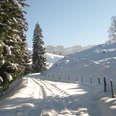
From the Innereriz snow sports center, near the Säge PostBus stop, the Rotmoos Trail starts towards Hindere Sol. After a short ascent, the Fallbach is crossed and you gently climb on the opposite side of the valley towards the Trüschhübel farm. From there, follow the trail to the holiday home. At point 1200 the ascent to Obere Breitwang begins, from where you can enjoy a magnificent view of the valley and far across the Emmental. In good weather, this viewpoint is suitable for a short break.
Along the gently descending ridge you then descend to the Rotmoos, the well-known nature reserve. The snowy, semi-open area hints at how unique it must be here in summer. In the area of the summer hiking path, you cross the Rotmoos and via Hängstli and Dräcker you then return to Innereriz.

Good to know
Pavements
Best to visit
Directions
Equipment
Directions & Parking facilities
Additional information
License (master data)
Safety guidelines
Map
Swisstopo map 1188 Eggiwil 1:25'000
Nearby

