- 4:00 h
- 9.45 km
- 760 m
- 760 m
- 1,586 m
- 2,196 m
- 610 m
- Start: Schwarzbach
- Destination: Schwarzbach
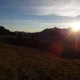
From the Schwarzbach parking lot (P. 1586 m) follow the alpine road to the Ällgäuli alp. Behind the alpine hut keep left and follow the signs upwards towards the Hohgant. Always keeping left, shortly before the lowest saddle between Hohgant and Furggegütsch, you reach the junction which leads left to the Hohgant summit. We first choose the path on the right and reach the highest point of the Hohgant massif, the 2197 meter high Furggegütsch. After the short but steep ascent, a first rest with a wide view over the Swiss plateau is well deserved.
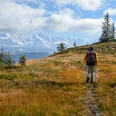
To reach the Hohgant itself, take the same path back to the fork at the saddle and after about 30 minutes stand on the Hohgant. It features a surprisingly wide, stony-grassy summit plateau – in fog orientation can be difficult here. In good weather, the view into the distance is impressive. Following the white-red-white trail markings, the return path leads down over the long southern ridge, initially scattered with many rock blocks, to the junction P.1739 at the Stand. The alpine road used for the ascent is soon reached and leads back to Schwarzbach.
Please observe the following rules of conduct!

Good to know
Pavements
Best to visit
Equipment
We recommend the following equipment: sturdy mountain boots, a medium-sized backpack with hip belt, sun protection, rainwear, trekking poles, a first aid kit, picnic, sufficient fluids, mobile phone.
Directions & Parking facilities
Arrival: by car to the Schwarzbach parking lot, toll road via Habkern and Lombachalp. If arriving by public transport, start at Lombachalp (2 hours additional); by bus from Interlaken-West station via Habkern to Lombachalp.
Return: by car or by bus from Lombachalp to Interlaken-West station
Additional information
Bernese Hiking Association, Bern, Tel.: 031 340 01 01, E-Mail: info@beww.ch, Homepage: www.bernerwanderwege.ch
License (master data)
Safety guidelines
This route runs partly or entirely on mountain hiking trails.
Nearby