


- 4:30 h
- 11.51 km
- 402 m
- 1,034 m
- 1,198 m
- 2,117 m
- 919 m
- Start: Engstlenalp
- Destination: Gadmen
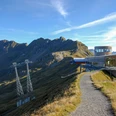
From the post bus terminal at Engstlenalp, it first goes gently uphill on a wide track to Engstlensee. Magnificent is the view over the blue-green shimmering water to Jochpass and Titlis area. Down-valley various mountain ridges are bypassed. From Scharmad, you enjoy the splendid view through the wooded, quiet Gental to the peaks of the Oberland ice giants.
The path runs almost horizontally above the treeline through the very steep mountainside downvalley to Bäregg (to Schwarzental 1h15, to Engstlenalp 2h).
Now gently ascending it goes through open terrain below Tällistock. Near the rocks, caution is advised in early summer in the steep avalanche slopes. From Sätteli you enjoy a magnificent view: firn and ice, forest and pasture, from the climbing mountains of the Engelhörner to the Finsteraarhorn and over the gleaming glaciers of Trift, Sutenhorn, and Titlis everything lies openly.
The following descent between rock bands is very steep but harmless.
The second part of the ridge hike leads from point 1847 with slight ups and downs past the Tällihütte (to Birchlaui–Nessental 1h30) and along the towering rock towers of Gadmerflue via Alpligen to Raflue (via Mettlenberg–Wenden to Feldmoos/Post bus 2h15). Here begins the rapid descent on a zigzag path into Gadmen, 400 m lower.

Good to know
Pavements
Best to visit
Directions
Engstlenalp - Bäregg - Sätteli - Tällihütte - Gadmen
Equipment
We recommend the following equipment: sturdy mountain boots, medium-sized backpack with hip belt, sun protection, rainwear, hiking poles, first aid kit, picnic, sufficient fluids, mobile phone.
Additional information
Association Bernese Hiking Trails, Bern, Tel.: 031 340 01 01, e-mail: info@beww.ch, homepage: www.bernerwanderwege.ch
Literature
Hiking suggestion from the Jungfrau Region Brienzersee - Oberhasli hiking book, hiking book series of the Bernese Hiking Trails
License (master data)
Safety guidelines
This route runs entirely or partly on signposted trails of the mountain hiking path category.
Map
Swisstopo hiking map 1:50,000 255T Susten Pass
Nearby
