- 4:10 h
- 9.50 km
- 860 m
- 860 m
- 1,521 m
- 2,241 m
- 720 m
- Start: Axalp
- Destination: Axalp
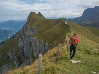
From Axalp follow the signage to Chüemad alternating between alpine road and hiking trail. Here turn left and ascend via Oberboden to the flat summit ridge of Tschingel. Here we are already in the area of the Axalp military firing range. In autumn, the air force conducts shooting exercises here and in October the two-day public air force shooting regularly attracts a large audience. During the shooting exercises, the hiking trails are closed and the access is guarded by the army. Past the small mountain station of the army railway, you reach the ridge with the distinctive tower. Shortly afterwards the official hiking trail branches off to the right towards Sattel. To climb the summit of Axalphorn, however, stay left and follow the path along the ridge and below the west summit up to the main summit. The last ascent is exposed and requires some scrambling and full concentration.
From the summit go back to the junction just before the military buildings. Descend into the slope of Scheitegg to the Sattel trail junction. The cable-secured descent to the north over karst rock requires concentration again due to the partly sharp and slippery rocks. At the Urserli junction turn left, then descend along a scenic high trail above the Hinterburgseeli to the houses at Chruttmettli. Here you deserve a break in the beautifully located Restaurant Hilten. From here to the endpoint Axalp is not far. First a stretch downhill over beautiful meadows and into the forest. Here you meet the Schnitzlerweg, which leads from Axalp to Hinterburgseeli. We follow it in the opposite direction back to Axalp.
Good to know
Pavements
Best to visit
Directions
Equipment
Directions & Parking facilities
Arrival: by bus from Brienz station to Axalp, stop Sportbahnen
Return: by bus from Axalp, stop Sportbahnen to Brienz station
Additional information
Literature
License (master data)
Safety guidelines
Map
Nearby


