


- 1:15 h
- 5.99 km
- 220 m
- 1,051 m
- 1,337 m
- 286 m
- Start: Bissen, valley station Wasserengratbahn
- Destination: Gstaad, station
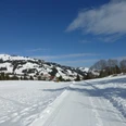
In the first part to Bissen, the hike impresses with wonderful views of Gstaad and the surrounding valleys and nearby hill ranges. Via the individual farms of Trom you descend to the Louwibach. Following the summer hiking trail, the path always leads along the wintry stream to the Litzi / Louwibach bridge car park in Gstaad. Here the winter hiking trail ends. Through the traffic-free promenade you reach Gstaad station in a few minutes.

Good to know
Best to visit
Directions
Valley station Wasserengratbahn - Bissen - Trom - Louwibach - Badweidli - Louwibach bridge - Gstaad station
Equipment
We recommend the following equipment: sturdy and waterproof mountain boots, light to medium backpack, cold protection, sun protection, hiking poles, pocket first aid kit, snacks, tea in a thermos flask, mobile phone.
Directions & Parking facilities
Additional information
Bern Hiking Association, Bern, Tel.: 031 340 01 01, E-mail: info@beww.ch, Homepage: www.bernerwanderwege.ch
License (master data)
Author´s Tip / Recommendation of the author
At the start of the winter hike, be sure to visit the Ski Club's Skipintli!
Safety guidelines
This route runs on cleared winter hiking trails.
Map
Nearby

