- 2:30 h
- 6.07 km
- 150 m
- 150 m
- 1,163 m
- 1,310 m
- 147 m
- Start: Kandersteg, Station square
- Destination: Kandersteg, Station square
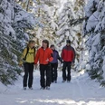
The Lötschberg railway line was originally laid out so that it did not cut the village of Kandersteg in two. It hugs the western side of the valley. The majority of the settled area lies on its eastern side. To the west of this, above the station area, is the area Uf der Höh, which with its deeply incised erosion slopes gives an inhospitable, indeed downright repellent impression from the village. However, this impression is deceptive, as the Höh invites you to an attractive circular hike.
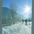
From the Kandersteg station head north towards the Stauwehr. The riverside path along the steaming Kander is appealing, whose riverside woodland is dusted with glittering hoarfrost crystals on cold winter days.
After passing under the Lötschberg railway line at the Stauwehr, the route initially follows a paved road, then branches off onto a forest path uphill. The sparse rays of the winter sun, which are especially appreciated in Kandersteg due to the towering surrounding mountains, can often only penetrate the dense forest for a short time during the ascent.
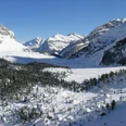
The actual site Uf der Höh is not accessible in winter. When walking the marked winter hiking trail, follow the pink signs that lead to the Höh location. From there, the short detour to Risetenegg is worthwhile – not a viewpoint in the classic sense, as the view is restricted on both sides by dense coniferous forest. To the east and south, however, there is a particularly attractive view of Kandersteg and the surrounding peaks. Through forest area and along the forest edge, the path leads down quiet forest trails to the houses of Bütschels. There, turn left towards the railway line and follow it to Kandersteg station, which is reached via the extended platform underpass.

Good to know
Pavements
Best to visit
Directions
Equipment
We recommend the following equipment: sturdy and waterproof mountain boots, a light to medium backpack, cold protection, sun protection, hiking poles, pocket first aid kit, snacks, tea in a thermos flask, mobile phone.
Directions & Parking facilities
Additional information
Bernese Hiking Trails Association, Bern, Tel.: 031 340 01 01, Email: info@beww.ch, homepage: www.bernerwanderwege.ch
Literature
Hiking suggestion from the hiking book Schneepfade in the Bernese Oberland, hiking book series of the Bernese hiking trails
License (master data)
Safety guidelines
Map
Nearby