- 5:45 h
- 12.89 km
- 1,030 m
- 1,480 m
- 958 m
- 2,314 m
- 1,356 m
- Start: Ramslauenen
- Destination: Mitholz
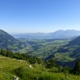
The alp breakfast at Ramslauenen high above the Kiental is a temptation that should be approached thoughtfully: impressive amounts of mountain cheese, young mountain cheese, ziger, ham and sausages are placed on the tables of the cozy guest room. But those heading uphill might prefer to indulge in this delicious adventure another time. From the chairlift mountain station, it mainly goes uphill, and quickly and consistently at that. Over alpine pastures and through mountain forest, you reach the Rüederigs junction on a steep path, and it continues just as steeply to the summit of Gehrihorn. The reward for the effort is abundant: wonderful panoramic view from Lake Thun over the Niesen chain into the front Kandertal valley and, to the east, onto the Kiental and the Blüemlisalp massif. After a short, partly somewhat exposed descent, the path leads to the Giesigrat, where the staffed ridge hut invites you to a snack. Afterwards, it goes uphill again. At the beginning, there is again a short exposed section. Experienced and sure-footed hikers will have no problems here. In wet weather or fog, great caution is advised at these points. The Giesigrat offers an impressive view down to Kandersteg. On a narrow rock path, you reach Höje Stand, then Obere Giesene, continue on the gravel-covered alpine road to Undere Giesene, and finally on a steep forest path to Mitholz.

Good to know
Pavements
Best to visit
Directions
Equipment
We recommend the following equipment: sturdy mountain boots, medium-sized backpack with hip belt, sun protection, rainwear, hiking poles, first aid kit, picnic, sufficient fluids, mobile phone.
Additional information
Bernese Hiking Association, Bern, Tel.: 031 340 01 01, Email: info@beww.ch, Homepage: www.bernerwanderwege.ch
Chairlift Ramslauenen: kiental-sesselbahn.ch
License (master data)
Safety guidelines
Map
Swisstopo hiking map 1:50,000 254T Interlaken and 253T Gantrisch and 263T Wildstrubel
Nearby