


- 5:30 h
- 13.00 km
- 1,180 m
- 800 m
- 1,211 m
- 2,378 m
- 1,167 m
- Start: Lenk, Pöschenried
- Destination: Lenk, Iffigenalp
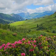
The route starts at the Alpenrösli bus stop (the restaurant of the same name is closed). After a few slightly ascending minutes on foot along the Iffigbach, the impressive Iffigfall is reached. The rushing water shoots more than 100m vertically into the valley here. From here, the hiking trail steadily ascends. After the Vierschild hut, the route follows the Iffigenalp road for a few meters instead of the Iffig hiking trail before the route goes straight ahead in the first 180° curve towards Alp-Pöris. The further into the valley the Alp road is followed, the narrower the path becomes until a narrow mountain path leads up to Hohberg on the left. This long mountain ridge convinces with its plant diversity and the beautiful view of the surrounding mountains in every season. Edelweiss, gentian, and numerous other rare alpine flowers often bloom here in the Gelten-Iffigen nature reserve. The hiking trail follows the mountain ridge up to the Iffighore. The mountain panorama at the summit is breathtaking. To the north lies the Obersimmental with many mountain peaks; to the south, the rugged rock faces of Mittaghore and Schnidehore are within reach.
On the descent, over a steep grassy slope, the next highlight becomes visible. The Iffigsee lies nestled at about 2000 m above sea level and is a true place of power. The lake’s surface shimmers turquoise on some days, dark blue in the light on others. The path winds along the slope above the lake and then descends steeply through the Iffig valley to Groppi. The last stretch to the Iffigenalp restaurant is walked on a not-so-steep alpine road. From here, the bus comfortably brings hikers back to Lenk.

Good to know
Pavements
Best to visit
Directions
Equipment
Directions & Parking facilities
Outbound: by train to Lenk. Then by Iffigalp bus to Pöschenried stop
Return: from Iffigenalp by bus to Lenk
Additional information
License (master data)
Safety guidelines
Map
Swisstopo hiking map 263T Wildstrubel 1:50000
Nearby

