- 4:25 h
- 12.55 km
- 250 m
- 1,200 m
- 1,274 m
- 2,230 m
- 956 m
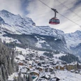
- Start: Grindelwald/Männlichen
- Destination: Wengen
From the mountain station of the Wengen–Männlichen cable car and the Grindelwald–Männlichen gondola, it is only a 10-minute walk to the summit of the Männlichen. This short detour is highly recommended, as it offers a fantastic panoramic view from the rather inconspicuous summit: to the south, the majestic triad of Eiger, Mönch, and Jungfrau towers, to the east lies the Grindelwald valley, to the west the Lauterbrunnen valley, while to the north the view stretches from the Schynige Platte over the Bödel and Lake Thun.
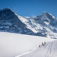
Those who know the ridgeway from Männlichen to Kleine Scheidegg in summer as a relatively easy walk without significant gradients should prepare for greater demands on this route in winter. From the Männlichen mountain station, the path starts with a brisk descent, then a flat section, and descends again crossing through the ski area. Caution and mutual consideration are required when crossing the slopes at Gummi. Winter hikers are guided well by the purple poles marking the path. The view of Grindelwald and the impressive north face of the Eiger richly compensates for the ski slope bustle. After passing the mountain station of the Tschuggen ski lift, hikers leave the ski slope area behind and enter an extensive quiet larch forest. In the Bustiglen area, the winter hiking route returns to the skier's domain. Cross several slopes with a short but steep ascent up to Kleine Scheidegg. After crossing the tracks of the Wengernalp and Jungfrau railways, the route continues with a gentle descent towards the Lauterbrunnen valley. While the first section from Männlichen to Kleine Scheidegg is unsuitable for sledding, the second stage down to Wengen is ideal for a sled run (those eager can rent sleds at Kleine Scheidegg). On the Wengernalp, the railway tracks are first crossed northwards, then shortly after underpassed again to the south, near the station building. Partly along the forest edge, partly through the forest, the route now continuously descends to the Allmend, where the railway line is crossed again.
The alpine path is sometimes quite narrow and used equally by sledders and hikers, requiring mutual consideration on both sides. Soon the first houses of the extensive mountain village of Wengen are reached, and after passing under the railway line again, you arrive at Wengen station, the destination of this extensive and very scenic hike.

Good to know
Pavements
Best to visit
Directions
Equipment
Directions & Parking facilities
Getting there: By train via Interlaken Ost to Lauterbrunnen and onwards to Wengen. From Wengen by cable car to Kleine Scheidegg.
Return journey: By train from Wengen.
Additional information
Literature
License (master data)
Safety guidelines
Map
Nearby