


- 4:00 h
- 10.13 km
- 700 m
- 700 m
- 2,161 m
- 2,647 m
- 486 m
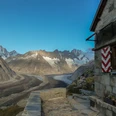
- Start: Grimsel Pass
- Destination: Grimsel Pass
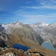
From the Grimsel Pass, follow the road for about 300 m towards Oberaarsee until the hiking trail signposted to Sidelhorn branches off to the left. Gaining altitude quickly, it is worth repeatedly looking back at the pass area with the Totensee. After about 250 meters of altitude gain, the Husegg hut is reached. Here we follow the signpost towards Oberaar and enjoy a magnificent view of the Lauteraar and Oberaar area. Slightly above the Triebtensee, the ascent to the Triebtenseelücke begins. A detour to the nearby lake, combined with a rest, is worthwhile here.
Refreshed, the path ascends gently to the Triebtenseelücke, which is simultaneously the Bern/Valais canton border. A last look back at the Bernese high Alps with the imposing Finsteraarhorn, and the panorama changes towards the southern Alps. The following descent to the Jostsee follows very beautiful paths. Only in the uppermost part caution is advised, as snow often persists here for a long time.
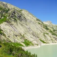
The small Jostsee appears somewhat inconspicuous from a distance, but the closer one gets, the more interesting it becomes. The moss-covered inflows and the white cotton grass convey a mystical atmosphere in the magnificent mountain world.
The mountain trail then leads back towards the Grimsel Pass. Passing abandoned crevices and beautiful high moor meadows, you soon reach the Chrizegge. Here there is a beautiful view of the Totsee and the busy activity at the pass crossing, our hiking destination.

Good to know
Pavements
Best to visit
Equipment
Directions & Parking facilities
Arrival: by bus from Innertkirchen, Grimseltor station to Grimsel, pass height
Return: by bus from Grimsel, pass height to Innertkirchen, Grimseltor
Additional information
Literature
License (master data)
Safety guidelines
Map
Nearby