


- 3:00 h
- 5.05 km
- 400 m
- 400 m
- 1,637 m
- 1,952 m
- 315 m
- Start: Chrindi
- Destination: Cheibehorn
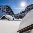
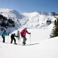
From the middle station Chrindi the route leads via the winter hiking trail to the Hinderstockenalp area. After the junction, follow the summer hiking trail to point 1764, where the path turns right and first climbs steeply, passes below the Cheibehorn through a small snow valley up to the height at the signpost location with the junction towards Cheibehorn. To this magnificent viewpoint, the track leads over the narrow ridge. From the summit, the view extends south to the Bernese Alps and northwest to the Gantrisch range. The same way leads back to Chrindi.

Good to know
Pavements
Best to visit
Directions
Chrindi - Hinterstockenalp - Cheibehorn - Hinterstockenalp - Chrindi
Equipment
We recommend the following equipment: sturdy and waterproof mountain boots, light to medium backpack, cold protection, sun protection, hiking poles, small first aid kit, snacks, tea in a thermos flask, mobile phone.
Directions & Parking facilities
By train via Spiez to Erlenbach. Take the Stockhorn cable car to the middle station Chrindi.
Additional information
Association Berner Wanderwege, Bern, Tel.: 031 340 01 01, E-mail: info@beww.ch, Homepage: www.bernerwanderwege.ch
License (master data)
Author´s Tip / Recommendation of the author
Shoes can be rented at the middle station of the Stockhorn cable car.
Safety guidelines
This route is signposted as a snowshoe route but not specially prepared.
Map
Swisstopo topographic map 1207 Thun 1:25,000, order at: https://www.wanderplaner.ch/sommer/web-shop/
Nearby


")
")
")