


- 2:10 h
- 3.61 km
- 230 m
- 230 m
- 1,776 m
- 1,776 m
- 0 m
- Start: Chrindi
- Destination: Oberstockenalp
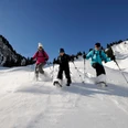
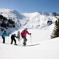
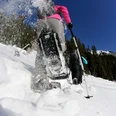
The route leads over the winter hiking trail to the Hinderstockenalp area, where the path branches off towards Oberstockenalp. In varied terrain, the path first ascends in the open terrain, then along the slope through the fir forest to the alpine hut of Oberstockenalp. The same track leads back to the starting point.

Berner Wanderwege
Good to know
Pavements
Path
Trail
Best to visit
suitable
Depends on weather
Directions
Chrindi - Hinterstockenalp - Oberstockenalp - Hinterstockenalp - Chrindi
Equipment
We recommend the following equipment: sturdy and waterproof mountain boots, light to medium backpack, cold protection, sun protection, hiking poles, pocket first-aid kit, snacks, tea in a thermos flask, mobile phone.
Directions & Parking facilities
By car to Erlenbach in the Simmental valley (valley station Stockhorn cable car)
Stockhorn cable car parking lot
Outbound and return journey: by Stockhorn cable car to the middle station Chrindi
Additional information
Bern Hiking Association, Bern, Tel.: 031 340 01 01, E-mail: info@beww.ch, homepage: www.bernerwanderwege.ch
License (master data)
Author´s Tip / Recommendation of the author
Snowshoes and poles can be rented at the middle station of the Stockhorn cable car.
Safety guidelines
This route is signposted as a snowshoe route but is not specially prepared.
Map
Swisstopo topographic map 1207 Thun 1:25'000
Nearby

")
")
")