


- 4:30 h
- 12.87 km
- 420 m
- 830 m
- 1,130 m
- 1,919 m
- 789 m
- Start: Col du Pillon
- Destination: Feutersoey
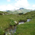
(Description in the opposite direction!) From the Feutersoey post office, first walk a few steps downhill along the main road. To the west, the deeply incised trench of the Tschärzisbach stands out, which indicates the direction to Arnensee. As soon as you reach the edge of the forest at the road, continue uphill over the Egg and ascend quite steeply to the crossroads on the Tuxberg (mountain variant via Hinter Walig–Blatti–Obers Stuedeli to Alp Seeberg 2h). Now, with slight ups and downs, continue over alpine pastures and through forest tongues to the Tschärzisbach at Linders Vorschess, locally called "Fleutenenläger."
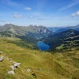
Here you pass through the area of one of the most significant viper colonies in the Western Alps. A forest path then first leads along the stream and then ascends to Alp Unters Stuedeli. Although there is also a direct (marked) connection to Seeberg from here, the small detour to the peaceful Arnensee is highly worthwhile. Briefly go down an alpine cart path to the dam, then past the "Huus am Arnensee" along the lake into the valley floor. According to tradition, the counts of Greyerz and their subjects from the Saanenland met here for a brief "mountain village." Today the lake is a popular meeting spot for fishermen and mountain hikers. An alpine path now leads steeply up in many hairpin bends to Alp Seeberg. Here, keep uphill between the two alpine buildings. Magnificent view over the lake into the Tschärzistal and to the Staldeflue. Again, the path climbs steeply and passes a small mountain lake to the lowest indentation in the terrain, the pass height of Col de Voré below Chalet Vieux. Wonderful view of the glacier-covered mountain world of the Diablerets. The path winds steeply downhill, following the slope through loose forest to Lac Retaud, a gem in the Vaud Prealps. Avoiding the little road, proceed steeply downhill through spruce and mountain pine forest, past peculiar hills and gypsum funnels to the pass height of Col du Pillon. Since 1998, the Diablerets railways have realized a large project here, whose attraction is the development of the firn field and glacier world at Sex Rouge.

Good to know
Pavements
Best to visit
Directions
Col du Pillon - Lac Retaud - Col de Voré - Arnensee - Feutersoey
Equipment
We recommend the following equipment: sturdy mountain boots, medium-sized backpack with hip belt, sun protection, rainwear, hiking poles, pocket first aid kit, picnic, sufficient liquid, mobile phone.
Directions & Parking facilities
Outbound trip: By post bus from Gstaad or Feutersoey to Col du Pillon
Return trip: By bus from Feutersoey to Gstaad
Additional information
Bernese Hiking Trails Association, Bern, Tel.: 031 340 01 01, Email: info@beww.ch, Homepage: www.bernerwanderwege.ch
Literature
Hiking suggestion from the hiking book Passwege in the Bernese Oberland, hiking book series of BWW
License (master data)
Safety guidelines
This route runs wholly or partially on mountain hiking trails.
Map
Swisstopo hiking map 1:50,000 263T Wildstrubel
Nearby
