- 4:50 h
- 11.47 km
- 1,090 m
- 1,090 m
- 1,039 m
- 1,969 m
- 930 m
- Start: Innereriz
- Destination: Innereriz
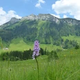
From the bus terminus Innereriz/Säge, follow the road initially downstream, turn left after a few minutes at the holiday home settlement, and quickly gain elevation in the forest. The path then continues gently with wonderful views of Sieben Hengste, Sichle, and Burst to the signpost at Ferienheim. On a wide alpine path, ascend to Obere Breitwang, where you turn right and cross the western flank of the Trogenhorn. In the forest, you rapidly gain height in wide, moderately steep switchbacks. Later, on a narrow mountain path over exposed sheep pastures, ascend very steeply. The last section to the summit and the following short descent to the saddle-like notch at its base passes over numerous rough rock blocks with deep gaps between them – this section is suitable only for experienced, sure-footed, and fearless mountaineers. Alternatively, a hillside path is available that bypasses the summit to the east.
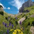
Through a steep couloir equipped with ladders, over sloping sheep pastures, and finally over wide moorlands, you reach the Chrinde. Here the path turns back towards Eriz. As a narrow trail, it runs over partly exposed rocky grassy slopes and through extensive scree fields to the huts at Obere Breitwang. The remaining path back to Innereriz follows the same route as the ascent.

Good to know
Pavements
Best to visit
Directions
Innereriz-Obere Breitwang-Trogenhorn-Innereriz
Equipment
We recommend the following equipment: sturdy mountain boots, medium-sized backpack with hip belt, sun protection, rainwear, hiking poles, pocket first aid kit, picnic, sufficient fluids, mobile phone.
Additional information
Verein Berner Wanderwege, Bern, Tel.: 031 340 01 01, E-mail: info@beww.ch, Homepage: www.bernerwanderwege.ch
Literature
Hiking book Thunersee-Frutigland of the Bernese Hiking Trails
License (master data)
Safety guidelines
This route runs wholly or partly on marked trails of the mountain trail category
Map
Swisstopo hiking map 1:50,000 254T Interlaken
Nearby