


- 3:15 h
- 6.32 km
- 450 m
- 430 m
- 1,023 m
- 1,468 m
- 445 m
- Start: Eriz, Rüttegg
- Destination: Innereriz, Geissegg
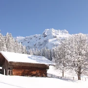
The Eriz Trail starts in the district of Rüttegg near the Eriz/Linden bus stop. From Rüttegg, the snowshoe route rises gently, passing the Alp Vorderezugschwand to the first height. Wonderful views open again and again into the Zulgtal and far out into the Mittelland. Through a small wooded section, you reach the Alp Vordere Schöriz. Then the path steadily climbs to Stouffeli. The idyllic hut below the Stouffe ridge offers a wonderful wide view and invites you to linger.
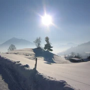
Freshly strengthened, you quickly manage the last climb up to the ridge. The view is now magnificent over the Sieben Hengste and the entire mountain range around the Zulgtal. The descent leads over the Ober Schöriz and Vordere Schöriz alps through open, pristine, and deserted landscape. Along the snow-covered alp road, you reach Geissegg. This is where the snowshoe route ends. Past the Zulgtal sales shop with regional products, Innereriz and the Säge bus stop are soon reached.

Good to know
Pavements
Best to visit
Directions
Equipment
Directions & Parking facilities
Inbound travel: By STI bus from Thun train station to Eriz/Linden. Then on foot to Rüttegg
Return travel: From Innereriz Säge by STI bus to Thun
Additional information
License (master data)
Safety guidelines
Map
Swisstopo national map 1207 Thun and 1208 Beatenberg 1:25’000
Nearby
