

- 3:40 h
- 10.82 km
- 500 m
- 340 m
- 1,486 m
- 1,712 m
- 226 m
- Start: Isenfluh/Sulwald
- Destination: Mürren
The densely packed houses of the village centre of Isenfluh partly show facade paintings typical of the Frutigland region. Up in the small village, at the former Hotel Jungfrau (today Geneva Bible School), the view to the Jungfrau group is incomparably beautiful. Now turn towards the slope from the little street and climb many zigzag bends, without crossing the stream, through loose woodland up to Sulwald (5 min to the cable car station). Anyone stepping a few steps out of the forest will again experience a magnificent view of the mountain world of the Lauterbrunnen valley.
Climbing somewhat more gently, then again over a steep section, you reach the rocky ridge of Chüebodmi and thus also the highest point of the hike (45 min to Suls–Lobhorn hut; 2h via Suls–Sousegg to Sousläger). Deep cracks in the rock base indicate the constant movement of the rock masses. Over the karstified alpine pasture it then goes slightly downhill to the Sulsbach and after crossing it – partly in the forest – valley inward into the Soustal. Above the flat pastureland of the Soustal stand the vertical rock layers of the Gälbe Schopf, and far back in the valley the summit of the Schilthorn becomes visible. On a narrow footbridge it goes over the Sousbach and slightly rising to the upper huts in Sousläger. In a hollow down to the left lies the Flöschwaldseeli, surrounded by dark fir trees. Always slightly descending, the path now winds around the outcrop of the Marchegg through the Spryssewald to the railway station on Grütschalp high above the Lauterbrunnen valley. Without significant ascent then follows a broad promenade path to the gurgling and swirling young Staubbach and through beautiful mountain forest to the Winteregg station. Soon the path runs parallel to the railway line and leads effortlessly to the world-famous mountain spa resort Mürren.
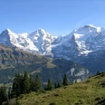
The views across the valley to Wengen, to the Männlichen ridge and to the Jungfrau group enchant hikers anew each time, and encounters with grazing chamois are not uncommon here either.

Good to know
Pavements
Best to visit
Directions
Isenfluh - Chüebodmi - Sousläger - Grütschalp - Mürren
Equipment
We recommend the following equipment: sturdy mountain boots, medium-sized backpack with hip belt, sun protection, rainwear, trekking poles, first aid kit, picnic, sufficient fluids, mobile phone.
Directions & Parking facilities
Outbound journey: by train via Interlaken Ost to Lauterbrunnen. Then by bus to Isenfluh.
Return journey: by train from Mürren to Grütschalp and by gondola to Lauterbrunnen station.
Additional information
Bernese Hiking Trails Association, Bern, Tel.: 031 340 01 01, E-Mail: info@beww.ch, Homepage: www.bernerwanderwege.ch
Literature
Hiking proposal from the Jungfrau Region Brienzersee - Oberhasli hiking book, hiking book series of the Bernese Hiking Trails
License (master data)
Safety guidelines
This route runs entirely or partly on marked paths of the mountain hiking route category.
Map
Swisstopo hiking map 1:50,000 254T Interlaken
Nearby


")