


- 4:50 h
- 14.78 km
- 386 m
- 788 m
- 1,230 m
- 1,861 m
- 631 m
- Start: Sparenmoos
- Destination: Schönried
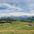
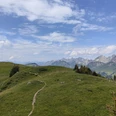
From the former mountain lodge Sparenmoos (1632 m), follow the signs towards Hundsrügg, which initially leads gently uphill across the moorland of Tolmoos and Nüjeberg. At Schiltenegg (P.1783), leave the road and ascend directly over the ridge to the summit of Hundsrügg. Here you enjoy a first view of the rock towers of the Gastlosen. Then continue southwestwards along the ridge with a splendid view. At the Luegle saddle, descend keeping right to Alp Bire and follow the high-altitude path past Alp Vorderi Schneit to the Chaltläger trail junction. Soon you reach the grassy saddle at P.1860, from where there is a wonderful panorama of the western part of the Bernese Oberland up to the steep rock peaks Le Rubli and Gummfluh. Shortly after that, Obers Rellerli (1833 m) is reached. Since the operation of the Rellerlibahn was discontinued in 2019, a possible stop at the mountain restaurant is unfortunately not available. Along the toboggan run, the scenic descent begins via the Rellerligrat. This continues over Alp Gspan (1552 m) to Grüebli, where you keep left and then descend via Scharlotti to Schönried.

Good to know
Pavements
Best to visit
Equipment
We recommend the following equipment: sturdy hiking boots, medium-sized backpack with hip belt, sun protection, rainwear, hiking poles, small first aid kit, packed lunch, enough fluids, mobile phone.
Additional information
Bernese Hiking Trails Association, Bern, Tel.: 031 340 01 01, E-mail: info@beww.ch, homepage: www.bernerwanderwege.ch
Literature
Hiking book Bernese Oberland of the Bernese Hiking Trails
License (master data)
Safety guidelines
This route runs entirely or partially on mountain hiking trails.
Map
swisstopo hiking map 263T Wildstrubel 1:50,000
Nearby
