


- 2:40 h
- 7.07 km
- 365 m
- 367 m
- 1,671 m
- 2,030 m
- 359 m
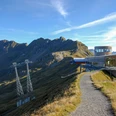
- Start: Käserstatt mountain station
- Destination: Käserstatt mountain station
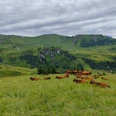
The alpine municipality of Hasliberg with the villages Hohfluh, Wasserwendi, Goldern, and Reuti has a considerable forest area as well as very large alpine pastures (e.g. Balis, Mägis, Gummen, and others). A total of 1200 livestock units can be grazed here for 100 days.
From Berghaus Käserstatt you head gently descending westward over marshy areas into the hollow of Balisalp. Near the houses of Vordere Stafel, shortly after the confluence of the streams forming the Louwenenbach, turn uphill and quickly gain altitude via the flank of the Chingstuel. In the rockfall area, the forest road gradually becomes a path leading to the ridge of the pyramidal Gibel. The border mountain is bypassed on the Obwalden side and climbed without difficulty from the west without a path. The panoramic view from this lookout is overwhelming: over the Brünig Pass you can overlook Lake Brienz and the Brienzergrat in their full length. From the depths, Lake Lungern shines. To the north, you see into the Kleine Melchtal, while Hochstollen and Glogghüs limit the horizon to the east. To the south, peaks line up from the Hasli Valley to Central Switzerland and from the Wetterhorn to the Eiger. It is almost hard to part from this splendor. On the Gibelweg, it goes gently downhill to Schonegg between Gibel and Chingstuel and almost level above the wide alpine hollow back to Käserstatt (via Hohsträss–Hääggen 1h30).
The start and end point of this route is the Käserstatt mountain station, reachable by gondola or on foot. Please note the cable car's operating hours.

Good to know
Pavements
Best to visit
Directions
Equipment
Directions & Parking facilities
Arrival and return: By train to the Brünig Pass. From there by bus to Hasliberg/Twing. From Twing with the gondola to Käserstatt mountain station.
The start and end point of this route is the Käserstatt mountain station, reachable by gondola or on foot. Please note the operating hours of the cable car.
Additional information
Literature
License (master data)
Safety guidelines
Map
Nearby
