


- 3:10 h
- 9.43 km
- 198 m
- 960 m
- 1,161 m
- 2,030 m
- 869 m
- Start: Käserstatt
- Destination: Twing
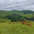
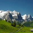
From the Käserstatt mountain station, follow the signs towards Gibel, which lead directly to the gently ascending and extremely scenic high trail. Upon reaching the flat Schonegg pass, the panorama widens towards the distinctive Güpfi and the Pilatus located to the right behind it. Fifteen minutes later, after reaching the Gibel, the view of Lake Brienz is added. If hiking in late summer, arrival at the 2035-meter-high grassy hill may be delayed due to walking through lush blueberry fields.
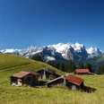
On the other side of the Gibel, we descend to the junction P.1982 and turn left to P.1976, where you can enjoy once again the outstanding panorama from the Hasli valley across the Bernese High Alps towards Interlaken. Over alpine pastures, the route then leads first on a hiking trail and then on an alpine road down to the alpine settlement Balisalp/Vordere Stafel. At the junction by the alpine huts (alpine cheese available), we keep to the right and follow the children's theme trail Muggestutz for 300 meters to the alpine restaurant Balisalp, where a stop is highly recommended (open only on weekends). From Balisalp, we follow the yellow signposts towards Lischen, the mid-station of the cable car. Taking the cable car down shortens the hike by half an hour. Those who hike down to Twing turn right about 300 meters before the mid-station, following the signs to Wasserwendi and later to Twing. Those wanting to stop at the Hasliberg bathing lake follow the panoramic trail towards Hohfluh in Wasserwendi. Shortly after the REKA holiday village, there is the beautifully located bathing lake with an associated bistro. From there, it is only a few meters down to the Twing valley station.

Good to know
Pavements
Best to visit
Directions
Equipment
Directions & Parking facilities
Paid parking at the valley station (parking garage) Wasserwendi
Round trip: by bus from Brünig Pass station to Hasliberg, stop Wasserwendi Twing
Additional information
Literature
Hiking book Bernese Oberland by Bernese Hiking Trails
License (master data)
Safety guidelines
Map
Swisstopo hiking map 255T Sustenpass 1:50,000
Nearby