- 3:50 h
- 9.70 km
- 750 m
- 780 m
- 1,486 m
- 1,958 m
- 472 m
- Start: Sulwald
- Destination: Grütschalp
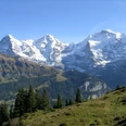
At the Sulwald mountain station we ascend towards the Lobhorn Hut through the Guferwald to the Alp Suls. Behind the Alp huts of Suls, we keep left towards Sulsseewli. Shortly after the mountain lake, we turn right and approach the Lobhorn Hut. A piece of finest apricot or hazelnut cake promises a treat for the palate and offers the eyes a breathtaking view of Eiger, Mönch and Jungfrau. We return directly to Alp Suls, from where we follow the well-known hiking trail for another 200 m, until it branches right over a bridge. Now we stay on the high trail to the Naterwengli crossroads (P.1785). We descend left to the Sousbach near Sousläger. Crossing the bridge, we ascend on the other side to the path junction P.1703, where we turn left. At the fork Läger (P.1767), we keep left again. This soon leads us into the Marcheggwald, which takes us down to the Grütschalp mountain station. Those who wish can hike from Grütschalp along the railway line to Mürren and have a nice opportunity to stop halfway at the Winteregg restaurant (additional 1 h 15 min).

Good to know
Pavements
Best to visit
Equipment
Directions & Parking facilities
Arrival: by bus from Lauterbrunnen station to Isenfluh village. From there by cable car to Sulwald
Return: from Grütschalp by gondola to Lauterbrunnen station
Additional information
Literature
License (master data)
Safety guidelines
Map
Nearby